
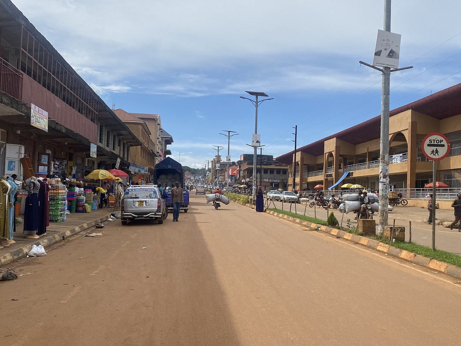
Masaka is where the southwestern safari road stops being a drive and starts being a trip, with the Equator behind you, a swimmable lake half an hour east and the Ssese ferry jetty at the end of the same tarmac. Most visitors pass through on a southwestern Uganda safari heading for Lake Mburo, Bwindi or the islands. Uganda’s fourth city sits about 132 km from Kampala on the Mbarara highway.
Masaka as a Stop on the Kampala to Mbarara Safari Route
Almost everyone who comes to Masaka is on the way somewhere else. That is not a criticism of the town, it is the town’s function, and grasping that is the fastest way to work out how much time to give the place.
Masaka is the last proper city before Mbarara, and it is the junction where three useful roads meet. The highway runs southwest towards Mbarara, Lake Mburo and eventually Bwindi and Kisoro. A good tarmac road runs east from Nyendo to the Bukakata jetty and the Ssese ferry. Another runs south through Kyotera to the Tanzanian border at Mutukula. If you are doing any serious driving in the southwest, you will end up here.
What that gives you practically is a regional referral hospital, banks with working ATMs, fuel you can trust, tyres, mechanics and supermarkets. On a road where the next town of any size is two hours away, that matters more than any attraction.
The last national census counted about 285,000 people inside the enlarged city boundaries, which took Masaka past Jinja into fourth place nationally. The old municipality held closer to 100,000, which is why you will see wildly different population figures online depending on which page quotes what. The city sits at roughly 1,290 m in the Buganda heartland, on red soil that grows coffee and matoke better than almost anywhere in the country.
So how long? Half a day if you are pushing on to Mbarara and want the market and Kitovu. One night if Nabugabo is on the plan. Two if you are taking the ferry to Ssese and would rather not do the drive and the crossing on the same day. Masaka is not a place you build a holiday around, and any page telling you otherwise is selling something.
Equator Tours at Kayabwe and the Road South to Masaka
The Uganda Equator tour at Kayabwe is the most photographed roadside stop in the country and the one most often misplaced. Get the geography right first, because it changes your planning.
Kayabwe sits in Mpigi district, about 72 km from Kampala, which puts it a good 60 km short of Masaka. Every travel page that files it under Masaka attractions is wrong. It is a stop on the drive down, taken roughly an hour into the trip, and if you have already reached Masaka you have passed it.
There are two painted circles and a cluster of craft shops, a coffee house and a couple of restaurants that have grown up around them. Twenty to forty minutes covers it. The shopping is better than you expect, with real handmade work among the printed shirts, and enough stalls that walking away from a price genuinely works.
Then there is the water demonstration, which deserves plain speaking. A guide sets up three funnels, one north of the line, one south, one on it, and shows you water draining anticlockwise, clockwise and straight down. The Coriolis effect is real. It does not do this. At the scale of a bucket it is overwhelmed by how the water was poured and how the funnel was tipped, and what you are watching is a skilled piece of showmanship rather than physics. Plenty of people enjoy it knowing that. Pay for it if you want to support the person doing it, and do not repeat it afterwards as science.
There is a second Equator marker in Uganda at Kikorongo, on the edge of Queen Elizabeth National Park. Travellers going that way often think they have missed the crossing. They have not, there are simply two.
The drive south itself is worth a word. The Kampala to Masaka road is good tarmac and heavily trafficked, carrying freight to Rwanda and Tanzania along with every tourist vehicle heading southwest. Clearing Kampala is the slow part. Beyond Mpigi it opens up through Buwama and Lukaya, past roadside stalls selling grilled tilapia and mounds of pineapple, with Lake Victoria appearing on the left before Lukaya. Overtaking trucks on rises is the main risk. Do not drive it after dark.
Lake Nabugabo Trips and the Swimming Question
Lake Nabugabo trips are the one genuine reason to spend a night in Masaka rather than driving through, and the reason is simple: you can get in the water.
Nabugabo lies about 20 km east of the city, reached off the Bukakata road, with the last few kilometres on murram. It is a satellite of Lake Victoria, cut off from the main lake by a sand bar roughly 2 km wide. The separation happened around five thousand years ago, with the sand deposits that now divide them dated to about four thousand. The lake itself runs 8.2 km by 5 km and is shallow, clear and tea coloured from the surrounding swamp.
That isolation produced something biologists care about a great deal. Of the nine haplochromine cichlid species in the lake, five are found nowhere else, having evolved since the separation. Speciation that recent and that well documented is rare anywhere on earth, and Nabugabo is one of the textbook cases. The wider wetland system covers 22,000 hectares and carries international Ramsar protection, holding several globally threatened bird species and, at times, more than half the world population of white winged black terns.
Now the swimming. Nabugabo has been described as free of bilharzia for decades, and that reputation is the single reason most Ugandans come. It is also the claim most worth handling carefully. There is no published monitoring programme I can point you to that confirms it year on year, and the surrounding district certainly is not free of the parasite. What is true is that the lake has no crocodile or hippo population to speak of, the water is clear and shallow, and generations of Kampala families have swum here without incident. Treat it as much safer than Lake Victoria rather than as certified safe, avoid the reedy margins, and if you swim anywhere in Uganda it is worth getting a bilharzia test a few weeks after you get home regardless.
Three separate beaches sit along the shore and they have different characters, which nobody tells you in advance.
Two practical notes from people who have stayed. Service is slow at all three, genuinely slow, and ordering food an hour or two before you want it is normal rather than rude. And the electricity tends to come on in the evening rather than running all day, so charge what you need to charge overnight.
Beyond swimming, the lake does canoeing, sport fishing, birding along the papyrus edges and some very good sunsets. Motor rallying has used the tracks around the lake for years, which is why you will occasionally arrive to find the place full of cars and mechanics.
Bukakata Ferry Trips to the Ssese Islands
Bukakata ferry trips are how most people reach the Ssese Islands, and the Masaka side of that crossing is where the planning happens. The islands have their own story and their own guide; this is the road and the boat.
The jetty sits at Bukakata, about 37 km east of Masaka on good tarmac. Coming from Kampala you turn off at Nyendo, just short of the city centre, and follow the road east past the Nabugabo turning. The crossing runs to Luku on Bugala Island, the largest of the Ssese group and the one with Kalangala town on it.
The two routes to Ssese are worth comparing once, since people pick wrongly. From Entebbe the MV Kalangala sails direct to Kalangala town, takes most of an afternoon, charges a fare and suits anyone arriving by air with no vehicle. From Bukakata the crossing is short, free and takes cars, but you have to drive to Masaka first. If you have a vehicle, Bukakata wins every time. If you do not, Entebbe saves you a road transfer.
On the Bugala side, Luku is about an hour from Kalangala town on a road that was rebuilt along with the ferry service. Boda bodas and shared vehicles meet the boat.
Masaka City Walking Tours: the Market, Kitovu and Bwala Hill
A Masaka city walking tour takes a morning and is flat, compact and unremarkable in the best sense. This is a working Ugandan city that almost no foreign visitor bothers to walk, which is exactly why it is pleasant to walk.
Masaka Central Market is the place to start. Matoke in quantities that explain why Buganda eats it three times a day, coffee, pineapple, tomatoes, fish brought up from the lake, and a craft section with barkcloth, basketry and drums. Prices are honest more often than not and the pace is easier than Kampala’s markets.
Kitovu sits on a hill just outside the centre and holds St Charles Lwanga Cathedral, seat of the Masaka Catholic diocese. The view back over the city from the cathedral grounds is the best in town and the walk up is twenty minutes. Catholicism runs deep here; the martyr the cathedral is named for was a Muganda page killed in the persecutions of the 1880s, and the diocese has been one of the most influential in Uganda since. Below it stands St Henry’s College Kitovu, a boarding school that has produced a long line of Ugandan public figures and which visitors are usually welcome to look at from the road.
Bwala Hill carries the Anglican counterpart, one of the oldest churches in the region, and the pairing of the two hills tells you something about how missionary competition drew the lines in Buganda. There is a main mosque in the centre too, and a scattering of smaller parish churches, several of them modern because the originals did not survive the war.
Camp Ndegeya, out of town, is an artists’ colony and sculpture park built around a working studio, and it is the most surprising thing in the district. It is informal, occasionally closed, and worth ringing ahead about. The old railway station, the golf club and the recreation grounds fill in the rest of the city’s shape: a colonial layout that grew, got flattened, and grew back.
Eat local. Masaka is in the heart of matoke country and the small places near the market do luwombo, groundnut sauce and steamed banana better than the hotels. The Ugandan rolex, an omelette rolled in chapati, is street food here as everywhere. Coffee is grown on the surrounding hills and at least one café in town roasts what is grown nearby.
War Damage, Rebuilding and the Liberation Grounds Tour
Walk through central Masaka and you will notice that hardly anything looks old. There is a reason, and it is the single largest gap in everything written about this town online.
In late February 1979, in the closing months of the war that removed Idi Amin, Tanzanian forces and allied Ugandan rebels attacked the garrison at Masaka. The town was shelled, the army position fell after light fighting, and what followed was deliberate: much of the commercial centre was levelled, in part as retaliation for what the Ugandan army had done during its earlier invasion of northwestern Tanzania. Close to half the buildings in the main trading area were destroyed. For years afterwards Masaka was described in the Ugandan press as a ghost town, a grid of streets with roofless shells along them.
It got worse before it got better. Masaka was besieged again during the bush war of the 1980s, with the garrison holding out until it surrendered towards the end of 1985. Reconstruction only really took hold in the decades after that, and it was slow. The police station, the courts and most of the ruined landmarks have since been rebuilt or replaced, and the city that stands now is the third version of itself.
The Liberation Grounds in the centre commemorate the end of the fighting and double as the city’s public space, used for rallies, independence celebrations and football. There is no museum, no interpretive centre and no formal tour. What there is, is a town where anyone over fifty remembers it and will talk about it if the conversation goes that way, and a skyline with almost no pre war buildings left in it.
None of this is an attraction and it should not be treated as one. It is the explanation for why a city of this size and age has so little visible history, and it is better to arrive knowing it.
Nabajjuzi Wetland Birding Tours and the Shoebill Search
Nabajjuzi birding tours take you into a papyrus swamp on the edge of the city that carries international protection and, on a good morning, a shoebill.
Nabajjuzi is a Ramsar site of about 2,144 hectares running through Masaka towards Mpigi and Sembabule. It is a working wetland rather than a reserve with a gate: the sole water source for more than half a million people in and around the city, a spawning ground for mudfish and lungfish, and a papyrus system dense enough to hold species that need nothing else.
The birding is the draw. Shoebill are present and are the reason serious birders stop, though nobody should promise you one; the reliable Ugandan sites for that bird are Mabamba and the Murchison delta, and Nabajjuzi is a bonus rather than a plan. What you are more likely to get is papyrus gonolek, papyrus yellow warbler, grey crowned crane, malachite kingfisher and a long supporting list. Sitatunga, the swamp antelope that walks on splayed hooves across floating vegetation, live in here and are seen occasionally at dawn.
Access is informal. There is no visitor centre and no marked trail, so you go with a local guide arranged through a Masaka operator or a birding contact, usually by canoe through the channels at first light. Wear something you do not mind soaking. The wetland is under real pressure from encroachment for brick making, farming and building, which is a live local argument and one your guide will have opinions about.
Coffee and Banana Farm Tours Around Masaka
Coffee farm tours around Masaka are the most underrated half day in the district and the easiest thing here to arrange at short notice.
The hills around the city grow robusta, which is Uganda’s dominant coffee and the country’s largest agricultural export by value. Several estates and cooperatives in the district take visitors through the whole sequence: the shaded plots where coffee grows under banana, the picking, the pulping, the drying yards, the sorting by hand and the roast. Ending with a cup on the farm makes the point better than any tasting room.
Matoke matters as much here. Buganda’s staple grows on every slope around Masaka and the district is one of the country’s main suppliers, with the lorries heading for Kampala loaded to twice their apparent capacity. A farm visit usually takes in both crops plus whatever else is in the ground: pineapple, which the region grows in quantity, coffee’s shade trees, beans, cassava.
Some of the arrangements run as rural homestead visits, where you eat with a family, help with something and see how a Ugandan smallholding actually balances its crops. These work best booked ahead through an operator who has an existing relationship with the household, rather than arriving and asking, and it is normal to contribute for the time and the meal.
Kasensero, Lake Birinzi and the Southern Lakeshore Trips
The southern lakeshore trips from Masaka run down through Kyotera towards the Tanzanian border and into country that very few visitors see. Set expectations properly: this is travel for the curious rather than sightseeing.
Kasensero is a fishing landing site on the western shore of Lake Victoria, around 65 km southwest of Masaka past Rakai. It is a busy port with something like fifteen thousand people, a crossing point for traders from around the lake, and a place with a particular weight in Ugandan history: it was here and at nearby Lukunyu that the country’s first cases of what became the HIV epidemic were recorded in the early 1980s. Rakai has carried that ever since, and the long running research partnership based in the district has changed how the disease is treated worldwide. It is not a tourist site, there is nothing built for visitors, and going to look at it as one would be wrong. Going because you are interested in the fishing economy of the lake, with a local guide and some manners, is a different thing.
Lake Birinzi is the quieter proposition, another small satellite lake in the same wetland complex as Nabugabo, with fishing villages on its edges and almost no infrastructure. Kasanje Forest, community managed, offers guided walks among indigenous trees with monkeys, butterflies and forest birds, and is the kind of small site that survives only because a village decided it should. Both reward a half day and neither will fill one on its own.
Further south, Mutukula is the main border crossing into Tanzania, roughly 110 km from Masaka. It is a working commercial post rather than a tourist route, and anyone crossing should have the East African visa position sorted beforehand. The road continues to Bukoba on the Tanzanian side of the lake.
Lake Mburo Safaris and Onward Routes From Masaka
A Lake Mburo safari is the nearest real game viewing to Masaka and the most common next stop, roughly two hours southwest along the Mbarara road.
The park gates at Nshara and Sanga sit about 100 km from the city. Mburo is the smallest of Uganda’s savannah parks and the only one with zebra in numbers, along with impala, eland, topi, buffalo, warthog and a very good hippo population on the lake itself. There is no elephant and the lion presence is marginal, so anyone expecting big game will be disappointed and anyone who wants to walk, cycle or ride a horse among wildlife will not be, because Mburo is the Ugandan park that allows all three. Boat trips on the lake are the reliable highlight.
Beyond Mburo the road runs on to Mbarara and then splits for Bwindi, Mgahinga and Kisoro in the far southwest, or for Queen Elizabeth to the northwest. Masaka is the natural first break on all of those routes if you leave Kampala late, and the natural last break coming back.
The other onward option is the ferry, which turns Masaka into the gateway for a few days on Bugala before carrying on. That combination, two nights on Ssese and then straight down to Mburo, is one of the better ways to start a southwestern trip and almost nobody builds it.
Getting to Masaka and Moving Around the City
The road from Kampala runs about 132 km southwest through Mpigi, Buwama, Kayabwe and Lukaya, tarmac the whole way and in reasonable condition. Two and a half hours is the optimistic figure and three and a half is the realistic one, because the first stretch out of Kampala can swallow an hour on its own. Leave early.
Buses run the route constantly and cheaply, with several operators using the Kampala terminals and the trip taking around two and a half to three hours. Shared minibuses cover the same ground with more stops. Coming from Entebbe airport, allow two and a half to three hours and note that you can bypass Kampala on the southern route if your driver knows it, which saves considerable time.
Within the city, boda boda is the default and a short hop costs almost nothing. Agree the fare first. Shared taxis run out to Nyendo, Kyotera and the Bukakata road, and a special hire car for the day is the sensible answer for Nabugabo, Nabajjuzi or a farm visit, arranged through any hotel. The roads to Nabugabo and the smaller sites turn to murram at the end and a vehicle with clearance is worth having in the wet months.
Public transport in and out is a test of patience rather than a problem. Minibuses leave when full, not when scheduled, and the fish and chapati sellers who surround the vehicle at every stop are part of the arrangement. Fuel is reliable in Masaka and thinner south of Kyotera, so fill up before heading for the border or the lakeshore.
Where to Stay in Masaka and the Best Time for a Trip South
Masaka’s accommodation is unglamorous and perfectly adequate, built for traders, government visitors and the backpacker traffic heading southwest.
Hotel Brovad is the established name in town, with a pool and the conference space that everything official uses. Several smaller hotels and motels sit around the centre at half the price. At the budget end, Masaka Backpackers and Elite Backpackers have both been running for years, both have gardens and pools of some description, and both function as informal information exchanges for anyone heading to Ssese or Bwindi. Out at Nabugabo the three beach properties offer cottages and camping in a much better setting than anything in town, at similar money, which is the argument for sleeping at the lake instead.
Book ahead only around major events and the school holidays, when Nabugabo fills with Kampala weekenders. Otherwise walking in works.
On timing, Masaka sits in the classic two rains pattern of central Uganda. Long rains fall from March into May, a drier spell runs June to August, a second wet period covers September to November, and December to February is dry and warm. Daytime temperatures stay between about 24 and 28 degrees year round with cooler nights, which at this altitude is as pleasant a climate as Uganda offers.
The dry months are better for everything involving murram: the Nabugabo access road, the farm tracks, the wetland edges. The rains do not stop you doing much in the city itself, since they come as afternoon storms rather than all day drizzle, and the countryside is at its greenest afterwards. For Lake Mburo game viewing, the drier stretches from June to August and December to February concentrate animals near water and are the stronger bet. For swimming at Nabugabo, any dry weekday.
Frequently Asked Questions About Visiting Masaka
Is the Equator at Masaka?
No, and this is the most repeated error about the town. The Kayabwe marker sits in Mpigi district, roughly 72 km from Kampala and about 60 km short of Masaka. You cross it around an hour into the drive south, long before you reach the city. Plan it as a stop on the way rather than a day trip from Masaka, because doing it from Masaka means an hour and a half of driving each way to stand in a painted circle. There is a second marker at Kikorongo near Queen Elizabeth National Park, which is why some travellers think they crossed the line twice.
Can I really swim in Lake Nabugabo?
People do, constantly, and it is the main reason Ugandans come. The lake has been described as free of bilharzia for decades and has no crocodile or hippo population worth worrying about, which is more than can be said for Lake Victoria a few kilometres away. That said, the reputation rests on long standing local knowledge rather than a published monitoring programme, so treat it as much safer rather than guaranteed. Swim in the open water off the sand rather than in the reedy margins, and if you have swum anywhere in Uganda, ask for a bilharzia test a few weeks after you get home. It is a simple blood test and the treatment is one dose.
How does the Bukakata ferry to Ssese work and what does it cost?
It is free, for foot passengers and for vehicles. Two boats work the Bukakata to Luku route, the crossing takes thirty to forty five minutes, and sailings run roughly hourly across the day with a reduced Sunday service. The jetty is about 37 km east of Masaka on good tarmac, turning off at Nyendo. Cars, trucks and tankers are all carried, so driving to Bugala is straightforward. Timetables do change, so confirm locally before committing to a tight connection, and do not plan to arrive at Bukakata late, because there is almost nothing there to sleep in.
Is Masaka safe?
Yes, with ordinary urban caution around the market, the taxi park and at night. One thing worth addressing plainly, since the travel pages all avoid it: several years ago rural sub counties in Masaka and neighbouring districts had a run of night attacks on households, mostly on elderly residents, which killed around thirty people over two months. It generated real fear, arrests were made, and the motive was never conclusively established. It has not recurred, it never involved visitors or the city centre, and it is not a reason to avoid the area. The genuine risks here remain the usual Ugandan ones: the highway after dark, overtaking freight, boda bodas without helmets, and malaria, which is present year round.
What does a night in Masaka cost?
Not much. The main hotel in town runs roughly fifty to eighty dollars a night with breakfast, the mid range places around twenty five to forty, and backpacker beds from under ten. The cottages at the three Nabugabo beaches sit between roughly fifteen and thirty dollars a night, which is why staying at the lake usually beats staying in town on value. A bus seat from Kampala is a few dollars, boda hops within the city are under a dollar, and a special hire car for a day of sites outside the city usually runs between forty and eighty. Meals at local places cost a few dollars. Rates move, so confirm before budgeting.
Is it worth stopping in Masaka at all, or should I drive through?
If your schedule is tight, drive through and stop for fuel and lunch. Masaka has no headline sight and pretending otherwise wastes your time. It becomes worth a night for three reasons: you want to swim at Nabugabo, you are catching the Ssese ferry and would rather not drive and cross in one day, or you left Kampala late and Mbarara is too far. Those are good reasons and they account for most visitors who stay. Building a holiday around the town itself is not something the place supports.
Where is the best birding near Masaka?
Nabajjuzi wetland, on the city’s edge, which is a Ramsar site holding shoebill, sitatunga, papyrus gonolek and papyrus yellow warbler among a long list. Go at first light by canoe with a local guide, since there is no gate, no trail and no visitor centre. Nabugabo’s papyrus margins are the second option and hold large numbers of white winged black terns in season along with kingfishers and herons. Neither is a substitute for Mabamba if shoebill is the specific target, but Nabajjuzi is a genuine chance and almost nobody birds it.
Why does Masaka look so new for an old town?
Because most of it was destroyed. Tanzanian forces and Ugandan rebels took the garrison here in early 1979 during the war that ended Amin’s rule, shelled the town and then levelled much of the commercial centre, partly in reprisal for the Ugandan army’s earlier invasion of northwestern Tanzania. Close to half the buildings in the main trading area came down. Masaka was besieged again in the mid 1980s during the bush war. What you walk through today was rebuilt over the decades that followed, which is why the churches on the hills are among the few older structures left standing.
How long does it take to drive from Kampala, honestly?
Plan three hours and be pleased if it takes two and a half. The distance is about 132 km on tarmac the whole way, which looks like a two hour run on paper, and the maps will tell you so. What the maps do not price in is getting out of Kampala, which can take an hour by itself in the morning, or the freight traffic heading for Rwanda and Tanzania that fills the road beyond Mpigi. Leave before seven and the drive is easy. Leave at nine and it is not.
Can I get to Lake Mburo as a day trip from Masaka?
Physically yes, sensibly no. The gates are around two hours away, so a day trip means four hours of driving plus park time, arriving well after the morning game viewing has finished and leaving before the evening starts. Mburo rewards a night inside or just outside the park, where you can do a dawn game drive, a boat trip on the lake and a walking or cycling safari, all of which are the point of that park. Use Masaka as the stop before it, not as a base for it.
Uganda Safaris works with Ugandan operators who actually run the southwestern road, with drivers who know how long the Kampala stretch really takes, guides who can arrange a dawn canoe on Nabajjuzi or a farm visit that the household has agreed to in advance, and current knowledge of the Bukakata sailings rather than a timetable copied off an old page.
A three day Ssese Islands trip uses the Bukakata crossing described above, which is the reason to sleep this side of the water.
A six day gorilla tracking route comes down this road with a stop at the Equator and opens at Lake Mburo. Compare what each operator includes, and ask directly for help fitting Masaka into a route that also takes in the islands or the park.
4 Places to Visit in This Area
Individual sites within reach of here, each with its own guide. Some are written up because the name circulates and the place does not, which is worth knowing before you plan a drive around one.
No operator on the marketplace currently lists a safari to Masaka.
See every Uganda safari