
Mountain Climbing in Uganda: Rwenzori, Elgon and the Volcanoes
Summit attempts on Margherita Peak in the Rwenzoris, which requires glacier travel and technical gear, and non-technical ascents of Wagagai on Mount Elgon.
Mountain climbing in Uganda means three summits: Margherita Peak in the Rwenzoris at 5,109 metres, Wagagai on Mount Elgon at 4,321 metres, and the volcanoes above Mgahinga. All are multi day and guided, with porters and fixed camps. Only Margherita involves glacier travel, crampons and fixed ropes, which is the honest line between a hard trek and a real climb.
Safaris That Include Mountain Climbing


A Guide to Mountain Climbing in Uganda
Mountain Climbing in Uganda: Three Summits Worth the Trip
Mountain climbing in Uganda means three objectives and no others: Margherita Peak in the Rwenzoris at 5,109 metres, Wagagai on Mount Elgon at 4,321 metres, and the volcanoes above Mgahinga on the Rwandan and Congolese border. All are multi day, all need guides and porters, and only one of them involves ice.
That last point separates this page from the hiking and trekking page. Plenty of walking in Uganda is long and hard without being a climb. What sits here is different: named summits, altitude that has to be managed, fixed camps booked in advance, and on Margherita a glacier crossing with rope and crampons.
None of the three is a technical mountaineering objective in the alpine sense. Margherita's upper section asks for basic glacier skills that a competent guide can teach on the mountain, not for prior climbing experience. What all three ask for is fitness across consecutive days in wet cold conditions, which turns out to be the harder requirement.
Rwenzori Mountains Climbing Expeditions to Margherita Peak
A Rwenzori climbing expedition is the hardest thing sold as a holiday in Uganda. The range runs along the Congolese border west of Kasese, and its high peaks carry the only glaciers left in the country.
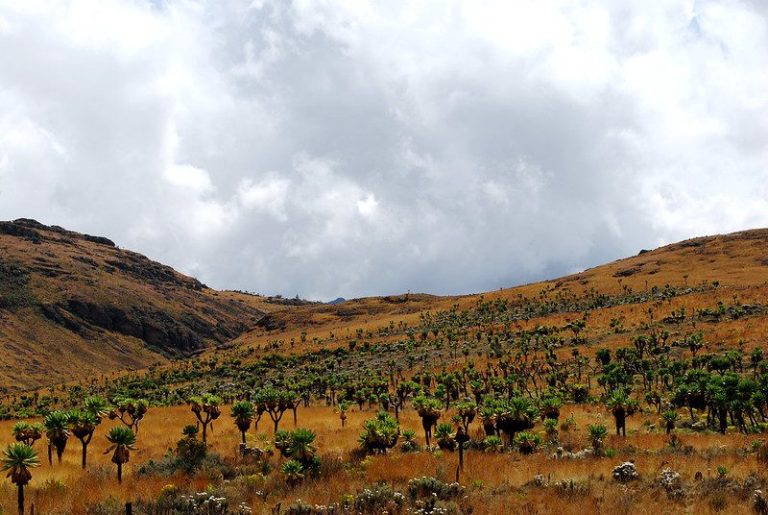
The walking is unlike anything else in East Africa. Roughly the first two days pass through montane forest and bamboo, then bog. The Rwenzori bogs are famous and deserve to be: tussock grass over black mud, crossed by stepping from clump to clump, with a fall into thigh deep water the price of a missed step. Above that comes the zone of giant groundsel and lobelia that makes every photograph of this range look faintly unreal.
Summit day starts in the dark from a high camp, crosses rock and then ice, and returns to camp by early afternoon if the weather holds. Weather is the variable that decides everything. This is one of the wettest mountain ranges on the continent and a summit attempt can be called off for conditions on any date in the calendar.
Our Rwenzori Mountains National Park guide covers the park itself, and Kasese is the town both routes start from.
Central Circuit or Kilembe: Choosing a Rwenzori Trekking Route
Two routes reach the high peaks and two separate organisations run them. This is the first real decision of the trip.
Whichever route you pick, the organisation running it supplies the guides, porters and hut bookings. An operator handles the arrangement and the transfers, but the mountain crew comes from one of those two bodies.
Glacier Travel on a Margherita Climbing Expedition
The final section is what makes this a climb rather than a trek. From the high camp you move onto the Stanley Plateau, rope up, put on crampons, and cross ice to the rock step below the summit. Fixed ropes cover the steepest part and a bridge has been built over a crevasse on the Margherita glacier, with additional ropes installed by the park and its partners.
No previous ice experience is required and guides brief the group on the mountain, but understate none of it: this is glacier ground at over 4,800 metres in poor weather, and clients are turned back on it every season.
The ice is also going. Glacier cover across the range has fallen by more than three quarters over the last hundred years, and mapping of the Stanley Plateau has recorded a further loss of close to thirty percent across a recent four year window. Mount Speke holds only static ice now and Mount Baker is close to bare. Researchers working on the range expect the remaining glaciers to be gone within decades. That is a documented trend rather than a sales line, and it changes the route description from one season to the next.
Mount Elgon Trekking to Wagagai and the Caldera Rim
Elgon is the gentler summit and a genuinely good one. Wagagai sits at 4,321 metres on the rim of a caldera that is among the largest on earth, and the walk to it crosses no technical ground at any point.
Routes come in from three sides. Sasa from Budadiri is the shortest at four days and the steepest, with over 1,600 metres of gain in the opening stretch. The Sipi trail runs five to six days and about 56 kilometres in and out. Piswa from the north covers roughly 49 kilometres over seven days at the kindest gradient, which makes it the sensible choice for anyone worried about altitude.
Once on top, the caldera itself is the reward: hot springs, the Jackson's Pool crater, and moorland running for kilometres with nobody on it. Most groups combine the summit with a night or two at Sipi Falls on the way out. The Mount Elgon National Park guide covers the park in full.
Mgahinga Volcano Climbing: Muhabura, Sabyinyo and Gahinga
The smallest national park in Uganda holds three volcanoes and all of them are climbed as single days, which is unusual and useful.
Muhabura is the highest and the hardest, a relentless slog up scree and tussock to a small crater lake at the top, eight to ten hours return with no flat ground. Sabyinyo is the one people remember: a ridge of rocky steps fitted with ladders, finishing on a summit where Uganda, Rwanda and the Democratic Republic of Congo meet. Gahinga is the shortest and wettest, ending in a swampy crater.
Weather is the catch. These peaks make their own cloud and a clear summit is a matter of luck. See the Mgahinga Gorilla National Park page for how the climbing fits alongside gorilla and golden monkey tracking in the same park.
Altitude and How a Uganda Climbing Expedition Is Paced
Margherita is high enough that altitude decides outcomes. Above 3,500 metres headaches and broken sleep are normal. Above 4,500 they stop being normal and start being a reason to descend.
Both Rwenzori routes build in height gain over several days, and Kilembe does it more gradually, which is its main argument. Elgon's Piswa trail exists for the same reason. The rule guides work to is simple: if symptoms worsen while resting, the answer is down, and there is no negotiation about it.
Evacuation is worth thinking about before you go. There is no helicopter rescue on the Rwenzoris in any dependable sense. A casualty comes off the mountain carried by porters, which takes days from a high camp. Travel insurance that covers trekking above 4,000 metres is the minimum sensible precaution.
Guides, Porters and Huts on a Rwenzori Climbing Trip
Porters are not optional on the Rwenzoris and nobody should want them to be. A standard party carries a guide, an assistant guide, a cook and one or two porters per client, and the rates are fixed rather than haggled. Tipping is expected at the end and operators will tell you the customary range if you ask.
Accommodation is huts on both Rwenzori routes and a mix of huts and camping on Elgon. Nothing is heated. Bunks, a communal space, a long drop outside. Kilembe's camps are newer and several have solar light. The Central Circuit huts are older and more basic, and Elena Hut in particular has a reputation for being cold and cramped, which is the price of its position below the glacier.
Sleeping bags, boots and waterproofs can be hired at the trailhead. Hire quality varies. Anything that touches your feet is worth bringing yourself.
Fitness and Gear for a Mountain Climbing Tour in Uganda
Training for this is not complicated. Walk uphill for several hours, repeatedly, carrying a day pack, on consecutive days. If that is comfortable at home you will cope here. If your hill walking has been one big day followed by a rest week, the fourth day on the mountain will find that out.
Gear splits into two lists. For any of the three summits: broken in boots, gaiters, waterproof jacket and trousers, layers for near freezing nights, gloves, hat, headtorch, and more dry socks than feels reasonable. For Margherita only, the mountain crew supplies the technical kit, crampons and rope included, and you should confirm what is provided before packing.
Wet is the theme. Rwenzori mud reaches mid calf on the bog sections and stays that way in the driest month of the year. Pack on the assumption that everything outside a dry bag will get soaked, because it will.
Best Months for a Rwenzori or Elgon Climbing Expedition
The drier windows are late December to February and June to August, and on both mountains they are the months operators push you towards. Trails firm up a little, cloud lifts more often, and the chance of a clear summit morning improves.
Understand what drier means on the Rwenzoris. It means less rain, not no rain. The range holds a reputation for wet weather in every month and parties have summited in April and been rained off in July. Elgon follows the pattern more predictably and its dry season is genuinely dry.
Our month by month timing guide covers the national picture, and since a summit attempt eats a week or more of an itinerary, the note on how many days you need in Uganda is worth reading before you commit.
Frequently Asked Questions About Mountain Climbing Tours in Uganda
How much does it cost to climb the Rwenzoris? The wildlife authority publishes a mountain hiking fee of USD 50 per person per day for a foreign non resident on both the Rwenzori routes and the Mount Elgon trails, and states that this figure includes park entry. Porters and cooks are charged separately at fixed shilling rates, in the region of UGX 40,000 and UGX 30,000 a day. On top of that sit the route organisation's own package, hut fees, food and transfers, which is why a full Margherita expedition is quoted as a package rather than a sum of parts. Rock climbing on Elgon is a separate line at a higher rate. The tariff is revised on a cycle, so take the figure for your dates from the operator rather than from any page, this one included.
Do I need climbing experience for Margherita? No prior mountaineering is required. You do need to be comfortable on steep ground, willing to walk roped on ice, and fit enough for consecutive long days. Guides teach crampon use on the mountain. Anyone nervous about the glacier can trek the route and stop below it, which several people in every party do.
How many days do I need? Seven to nine for Margherita on either route, four to seven for Wagagai depending on the trail, and one very long day for each Mgahinga volcano. Add a rest day afterwards before anything else in the itinerary.
How many parties reach the summit? Nobody publishes a reliable rate and anyone quoting one precisely should be questioned. What operators will tell you is that weather turns back more parties than fitness does, and that the groups who summit are usually the ones who allowed a spare day.
Is Mount Elgon a good alternative? For most people, yes. It is cheaper, shorter, drier, non technical and still takes you above 4,300 metres. The caldera is a genuine reason to go rather than a consolation.
Can I climb these mountains solo? No. Guiding is compulsory in all three parks and the Rwenzori routes are booked through the organisation that manages them. Independent walking is not permitted.
How cold does it get? Below freezing at the high camps on both big mountains, with wind chill on summit mornings. Daytime at lower altitude can be warm and wet at the same time, which is why layering matters more than any single heavy jacket.
Climbing trips here are run by independent Ugandan tour companies. Send your dates, the summit you want and an honest account of your fitness to the operator behind the trip that suits, and they will build the expedition and quote it properly. We take no booking and charge you nothing.