
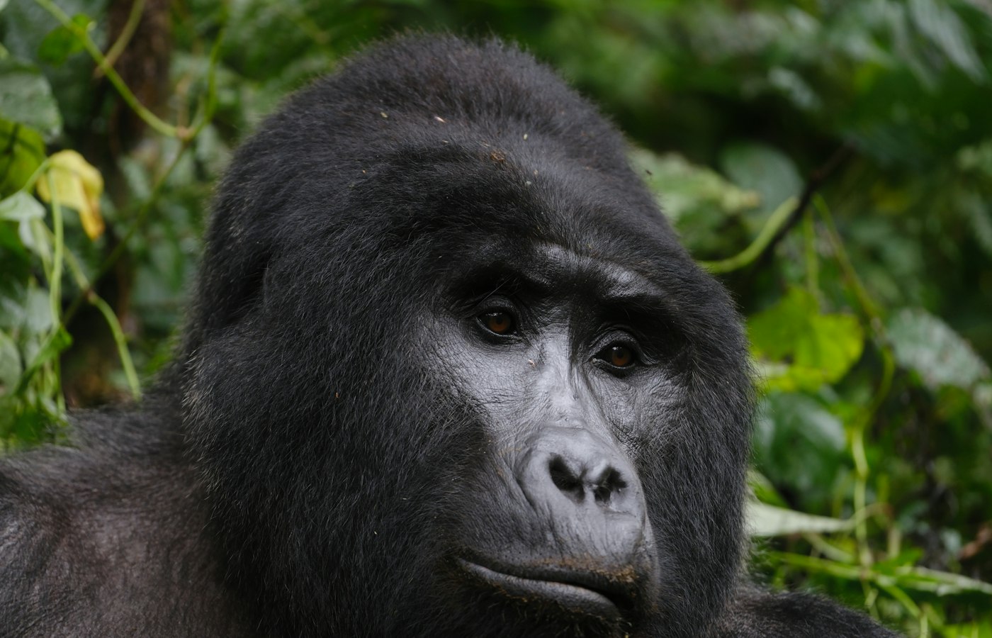
A Mgahinga Gorilla National Park safari is built around one habituated mountain gorilla family, the only golden monkeys in Uganda, three Virunga volcanoes you can climb in a day each, and a forest trail led by Batwa guides. Permits and activity slots are booked through the wildlife authority or a licensed operator, and Mgahinga sells out far less often than Bwindi. The park sits in Kisoro District, 33.7 square kilometres of volcano country on the Rwanda and DR Congo border.
Mountain Gorilla Trekking Safari in Mgahinga and the Nyakagezi Family
Mountain gorilla trekking at Mgahinga works differently from anywhere else in Uganda, and the difference is worth grasping before you book. One habituated group lives here, Nyakagezi, and about eight permits are released for it each day. Bwindi releases roughly two hundred across four sectors. So Mgahinga is not a volume operation. It is one small trek, one family, one morning.
Reporting is at the Ntebeko visitor centre, which the wildlife authority lists as the Ntebeko and Muhavura entry point. Briefing runs first, tracking starts at eight, and you walk with armed rangers and trackers who have usually been out since dawn following the group’s night nests. Uganda’s rules put a maximum of eight visitors with any gorilla group, hold the visit to one hour from the moment you reach them, and set the minimum age at fifteen.
The gorilla trekking safari here is often short. Nyakagezi ranges on the lower slopes of Muhavura and Gahinga and does not travel far in a day, so trip reports regularly describe reaching them inside an hour or two of leaving the gate. That is not a promise. The wildlife authority’s own figure for a Uganda gorilla trek is two to seven hours, and Mgahinga can produce a long one when the group has climbed.
What you get for the hour is a group with an unusual structure. Most gorilla families run under a single dominant silverback. Nyakagezi has carried several adult males together for years, which is rare enough that primatologists have written about it, and it means the hour tends to be busier than a family of one silverback and his females. Counts of the group shift with births, deaths and the odd male striking out, so treat any published number as a snapshot.
Then there is the thing every ranking page mentions in passing and none of them explains. Nyakagezi is a trans boundary group. The Virunga massif is one forest with three flags across it, and the family has historically moved into Rwanda and DR Congo for weeks at a time. It has been settled on the Ugandan side for years now and sightings are reliable, but the possibility does not vanish, and knowing where you stand is the difference between an inconvenience and a permit you cannot use.
Two conduct rules matter more than the rest and both are about disease. Stay ten metres back, which is the distance the wildlife authority prints on its own tariff card, and cover your face and turn away if you have to cough. No eating, no drinking, no smoking, no flash. Rangers enforce the ten metres properly, and if a young gorilla walks toward you the instruction is to stand still and let it pass rather than reach for a photograph.
Golden Monkey Tracking Safaris in the Mgahinga Bamboo Zone
Golden monkey tracking is the reason a good number of people come here rather than to Bwindi, and Mgahinga is the only place in Uganda you can do it. The species is confined to the Virunga massif and one forest fragment in Rwanda, nowhere else on earth. It carries an endangered listing, and the most recent regional conservation plan puts the Mgahinga population somewhere between roughly 470 and 1,500 animals, a wide band that tells you how hard they are to count in bamboo.
Ignore the figure of three or four thousand that circulates on several tour pages. It is not what the conservation planning says.
The tracking safari runs from Ntebeko into the bamboo belt that wraps the lower slopes, mostly between about 2,300 and 2,800 metres. Bamboo is why the walking is easier than a gorilla trek and why the sighting is harder work. You hear them before you see them, a rattle running through the canes, then flashes of orange and black overhead, then a troop settling to feed and giving you a clear look for a few minutes at a time. Troops of twenty or thirty are normal.
Photographers should set expectations low and shutter speeds high. The monkeys rarely hold still, the bamboo throws stripes of shadow across everything, and people who have done both consistently say the gorillas are the easy subject and the golden monkeys are the one that fills a card with blur. Anything longer than a short telephoto is more trouble than it is worth in that thicket.
There is also a golden monkey habituation experience, which puts you with the researchers working a troop that is not yet fully used to people, for longer than the standard hour. It is the quieter sibling of the gorilla habituation product at Bwindi and almost nobody markets it. If you want time rather than a tick, it is the better buy.
Mount Muhavura Hiking and Climbing Safari to the Crater Lake
Mount Muhavura is the highest of the three peaks inside the park at 4,127 metres, and the climb is the hardest day out at Mgahinga. It is a straightforward mountain in shape, a clean cone with no route finding to speak of, but it climbs roughly 1,600 metres from the trailhead and the last section is loose volcanic rubble at altitude. Most parties allow a full day, leaving around seven in the morning and getting back in the late afternoon, with the round trip covering something near 12 kilometres.
The name means guide in Kinyarwanda, from the way the cone stands over the whole Kigezi region and tells you where you are from fifty kilometres away. At the top there is a crater lake about 36 metres across, which is small enough to disappoint anyone expecting a lake and interesting enough if you understand you are standing in the vent of a volcano. On a clear morning the view runs across the Virunga chain into Rwanda and DR Congo and north toward the Bwindi hills. On most mornings there is cloud.
Altitude is the part people underestimate. Four thousand metres is high enough to give a fit person a headache and a slow pace, and the gradient offers no easy stretch to recover on. Anyone who has been at sea level for a week and lands in Kisoro two days before the climb is asking a lot of themselves.
Mount Gahinga Trekking to the Summit Swamp
Mount Gahinga is the smallest of the Virunga volcanoes at 3,474 metres and the one to pick if you want a volcano day without a punishing one. The trekking route runs about 8 kilometres round trip and most groups are back at Ntebeko inside six hours. It also gives the park its name. Gahinga is the local word for the piles of volcanic stones that farmers heap up when clearing a field, and the mountain is a very large version of the same thing.
The summit is not a peak but a swamp, a crater roughly 180 metres across that has filled with vegetation and holds water year round. Much of the walk is through bamboo, so this is the climb most likely to produce a golden monkey sighting along the way, and the saddles between the volcanoes hold the swamps that feed the streams every farm below depends on.
| Peak | Height | Typical day | Difficulty |
|---|---|---|---|
| Muhavura | 4,127 m | 8 hours | Hardest |
| Sabinyo | 3,645 m | 8 hours | Most exposed |
| Gahinga | 3,474 m | 6 hours | Easiest |
If you are only climbing one, the honest answer depends on what you came for rather than on which is tallest. Gahinga for a walk in bamboo with a decent chance of monkeys and knees that still work the next day. Sabinyo if you want the ladders and the three country summit and you are steady on exposed ground. Muhavura if you want the view and are genuinely fit. The times above are what parties normally take rather than an official figure, and weather moves them by hours in either direction.
Mount Sabinyo Climbing Adventure to the Three Country Summit
Mount Sabinyo is the oldest of the three, 3,645 metres, and the most eroded, which is exactly what makes the climbing adventure interesting. Where Muhavura is a smooth cone, Sabinyo has been chewed down into a jagged crest of separate peaks, and the name means old man’s teeth for that reason. The wildlife authority’s answer to the gaps between them is a series of wooden ladders bolted onto rock faces that would otherwise stop you cold.
You climb three peaks, with ladder sections up and down each. The summit sits precisely on the point where Uganda, Rwanda and DR Congo meet, so the party trick is standing in three countries at once, and it is the reason most people pick this mountain over the other two.
Trip reports from climbing clubs are blunt about the realities. The ladders get slippery in rain and the descent is worse than the ascent, because you are coming down wet rungs on tired legs. Groups have been caught out by weather and finished in the dark. Altitude sickness turns people back at the first peak with some regularity. Nobody who has done it describes it as a walk, and several recommend gumboots over hiking boots for the mud, which you can hire at the base rather than carry from home. A cut bamboo stick from the guides is worth more than a trekking pole on the ladders because you can drop it when you need both hands.
The Sabinyo Gorge walk is the low level alternative and a separate booking. It follows the gorge floor between the mountain’s shoulders through thick vegetation and is one of the better birding walks in the park, with no ladders and no altitude.
Batwa Trail Cultural Tours and the Garama Cave Adventure
The Batwa Trail is a guided cultural tour through the park led entirely by Batwa guides, developed by the Batwa’s own development union with the wildlife authority, and it is not a village visit staged at the gate. It is a forest walk on the ground the Batwa lived on before the park was declared. Most groups are out for four or five hours.
What happens along the way is practical rather than performed. Guides show you how a bow is drawn, where wild honey sits in a hive, which plants treat what, how a fire starts without a match, and how a shelter is built from what grows within arm’s reach. The tone is matter of fact, and the guides talk about their own eviction plainly if you ask.
The trail finishes at Garama Cave, and this is the part worth getting right because the ranking pages disagree. The park’s own management plan records Garama as roughly 342 metres long and about 14 metres deep. The figure of 200 metres that appears on some sites is simply wrong. It is a lava tube, formed when the outside of a flow cooled and the molten rock inside drained away, and the Batwa used it as a refuge, a kitchen and a place to dry meat, with a chamber set aside for their leader. There is standing water inside, which is why the plan also records that the Batwa themselves were wary of staying in it too long.
Inside the cave, Batwa women sing. It is not a song for tourists in any comfortable sense. It is about the forest they were removed from and their wish to go back to it, sung in the dark of a cave in the park that displaced them, and visitors who expected a folklore performance tend to come out quiet. Take the point seriously rather than filming it.
A shorter Batwa community tour runs outside the park boundary, visiting settlements and craft groups where the money goes straight to the households making the baskets and carvings. It is a different thing from the trail and worth doing alongside it rather than instead of it.
Birding Safaris in Mgahinga and the Virunga Highlands
Birding safaris at Mgahinga are about altitude specialists rather than long lists, and the numbers on competitor pages need untangling. The park’s management plan records 79 species confirmed inside Mgahinga itself. The wildlife authority’s park page publishes more than 180, and the neighbouring Rwandan park across the same forest has 185 recorded, most of which are expected to occur here too. Both figures are defensible. One counts what has been formally logged in a very small park, the other counts what the habitat holds. Fourteen Albertine Rift endemics are the reason birders come.
The birds to chase are the highland ones: Rwenzori turaco, Rwenzori double collared sunbird, handsome francolin, Kivu ground thrush, dusky crimsonwing, Archer’s ground robin, and the regional prize, the Grauer’s swamp warbler in the wet ground at the top of the bamboo. Because habitat here stacks in bands with altitude, a single day’s walk can move you through montane forest, bamboo, the Hagenia and Hypericum belt and into heath, and the bird list changes at each step in a way it never does on flat ground.
The gorge walk and the trail up toward the Muhavura and Gahinga saddle are the two productive routes. Go early, accept that mist will close in by mid morning for part of the year, and bring a guide who knows the calls, because in bamboo you will hear four birds for every one you see.
Short Walks and Nature Tours: Buffalo Wall, Border Trail and the Ntebeko Viewpoint
Not everything at Mgahinga needs a permit and a full day, and the short nature tours here are undersold. The viewpoint walk from Ntebeko is a gentle climb to a platform looking out over the volcanoes and the farmland below, priced as its own small activity and doable in a morning by anyone.
The Buffalo Wall is the strangest walk in the park and the most revealing. A dry stone wall about a metre and a half high runs along the park boundary where the boundary is not an international border, built to stop buffalo walking out into people’s crops. Of the 16 kilometres of boundary the park shares with its neighbours, the wall covers 11, from Nyakagezi to Rukongi. The remaining five kilometres toward the Rwandan border have no wall, and that is where the buffalo get out and the crop damage happens. Walking it, you are looking at the actual working edge of the conservation bargain rather than a brochure version of it.
The Border Trail runs along the international boundary through the saddles between the volcanoes, and the ground is soft, high and wet. Add the gorge walk and you have three or four days of walking here without ever buying a gorilla permit, which is a reasonable way to use Mgahinga if the permit is beyond you.
Wildlife and Volcano Country on a Mgahinga Safari
A Mgahinga safari is not a game drive park and there are no roads inside it to drive on. What lives here lives in forest and bamboo, mostly out of sight. The management plan records 39 mammal species confirmed, with an older survey suggesting as many as 89 actually occur, while the wildlife authority publishes a figure above 76. Nobody is being dishonest. It is a hard place to survey.
Beyond the gorillas and golden monkeys there are forest buffalo, giant forest hog, bushbuck, black fronted duiker and blue monkey. Elephant pass through occasionally. Golden cat, serval and leopard are on the list and are almost never seen. If somebody sells you Mgahinga on its leopards, find another operator.
That last line carries a cost that the park does not hide. When Mgahinga became a national park the Batwa, who had lived in this forest, were moved off it and were not given land in exchange. They are still landless in the villages below, which is why the Batwa Trail exists and why the money from it matters more than the money from most cultural activities you will be offered in Uganda.
Where your fees go is less abstract here than elsewhere. A share of park revenue is returned to the parishes bordering the park under the wildlife authority’s revenue sharing arrangement, and it funds the buffalo wall maintenance, water schemes and school building that make the park tolerable to farmers whose crops the buffalo eat. A gorilla permit is expensive. Some of it is doing that work.
Best Time for a Mgahinga Gorilla and Golden Monkey Safari
Mgahinga runs on two wet seasons and two dry ones, which is the pattern for this corner of the Albertine Rift and not the single long dry season people expect from a Uganda safari. The wet months are March into April and then September through December. The drier windows are January to February and May through August. The park is high, and it is often in cloud whatever the month, so temperature matters as much as rain. The management plan gives a range from about 18 degrees at the lowest ground down to around 4 degrees at the summits, with frost and hail on the tops.
Trekking runs year round. Nobody closes for rain. What changes is how hard the walking is and how many other people are on the mountain.
Use the chart rather than reading it. If you are here in April, May, October or November, take gaiters and expect to hire gumboots at the gate. If you are here in June, July or August, that is when a Muhavura or Sabinyo summit is worth the day, because a cloudy summit is a long climb for nothing.
Preparing for a Mgahinga Trek: Fitness, Altitude and What to Pack
The Mgahinga trek asks less of you than the same activity in Bwindi, mostly because the gorilla family is usually close and the ground is volcanic slope rather than tangled forest. That is the gorilla trek. The volcano climbs are a different order of effort entirely, and people who arrive fit for the first and casual about the second have a hard day.
Altitude is the honest constraint. The gate sits above 2,200 metres and Muhavura tops 4,100, so you are working in thin air from the moment you start. Arrive a day or two early, sleep at Kisoro or Lake Mutanda, and drink more water than feels necessary. If a headache arrives with nausea on a summit day, turning back at the first peak is the correct call and guides will support it without argument.
Long trousers and a long sleeved shirt in something that dries, tucked into boots. Stinging nettles are the recurring complaint on gorilla treks in this region and bare ankles suffer for it. Take gloves. Gardening gloves are the standard advice from people who have done it, because you will grab vegetation for balance and some of it bites. Gaiters keep mud out of your boots in the wet months. Rain jacket regardless of season, since the mist here turns to drizzle without warning.
Hire a porter. It is the single piece of advice that comes up most in trip reports, and the reason given is rarely the weight. A porter takes your bag, yes, but the real value is a steady arm on a slick descent and a hand on your back when the slope goes up. The fee is small, it is paid in cash at the gate, and it puts money directly into a household in Kisoro District. The same applies to gumboot hire at the base of the volcanoes.
Minimum age for gorilla tracking is fifteen and rangers check identification. There is no lower limit on the volcano climbs, but the altitude makes them unsuitable for young children in practice. Security in the border area is managed by armed rangers on every trek and has been stable for many years, though it is why you will notice more rifles here than in a park in central Uganda.
Getting to Mgahinga for Your Gorilla Trekking Safari
Mgahinga is 482 kilometres from Kampala by the wildlife authority’s own measure, and the drive takes around nine hours through Masaka, Mbarara and Kabale to Kisoro. It is tarmac almost the whole way now, with the last stretch to the gate on dirt.
Most people break the trip rather than doing it in one push, and Lake Mburo or Lake Bunyonyi are the usual overnight stops.
Flying is the alternative that changes the trip. Scheduled flights run from Entebbe and Kajjansi to Kisoro airstrip and take about an hour and ten minutes, against nine hours on the road. Add a short transfer at the far end and you have turned a two day slog into a morning. For a short trip built around a gorilla trekking safari, it is usually the difference between three days and five.
From Kisoro town the Ntebeko gate is roughly 14 kilometres on a road that has been improved and now takes well under half an hour in the dry. After heavy rain, allow an hour and want four wheel drive. A boda boda from Kisoro is the cheap option and locals use it routinely, though the road is rough and it is not the way to arrive for an eight o’clock briefing if you can avoid it.
Arriving from Rwanda is common and legitimate as a route. Kigali to Kisoro is roughly 165 to 180 kilometres and three to four hours by road, crossing at Cyanika, which is a small post rather than a busy one and typically operates from six in the morning to six at night. Once through, the gate is about half an hour away. Check the current visa position before you travel, since the East African tourist visa arrangement makes the crossing much simpler for some nationalities than others.
Where to Stay Near Mgahinga and How to Plan the Trip
There is no lodge inside the park. Everything sits along the road between Kisoro town and Ntebeko, or around the lakes north of town. The wildlife authority runs simple bandas at the Muhavura base for people who want to be at the trailhead. The community camp at Amajambere Iwacu, run by the neighbouring parishes just outside the gate, offers dorm beds, bandas and camping, and staying there is the most direct way of putting money into the villages that live with the park. At the top end there is a small lodge on the road in and several more upmarket options on Lake Mutanda, twenty minutes north of Kisoro, where you trade proximity to the gate for a view across the water at the volcanoes. Kisoro town itself has a spread of guesthouses and is the practical budget base. Camping inside the park is possible at designated sites with prior booking.
Now the question every visitor is actually asking and no page on this topic answers. Should you build a trip around Mgahinga, or is it a day out from somewhere else?
The honest answer is that Mgahinga rewards two or three nights and does not reward a week. With three nights based near Kisoro you can trek gorillas, track golden monkeys, climb one volcano and walk the Batwa Trail, which is the whole park properly done. Anyone with one night should treat it as a golden monkey and gorilla stop and skip the mountains. Anyone planning five nights should be spending some of them on Lake Mutanda or Lake Bunyonyi, or crossing to Bwindi.
Which brings up the comparison readers run in their heads. Bwindi against Mgahinga for gorillas is a genuine choice, not a formality. Bwindi Impenetrable National Park has more than twenty habituated families, hundreds of permits a day, four sectors of varying difficulty and the habituation experience that gives you four hours instead of one. Its forest is thicker, its treks are longer and its slopes are steeper. Mgahinga has one family, eight permits, open volcanic country you can see across, a usually shorter walk and hardly any competition for a booking. Add Uganda’s only golden monkeys and three climbable volcanoes and Mgahinga stops being the consolation prize. If you want certainty of choice and the full range of gorilla products, book Bwindi. If you want a quieter morning, a shorter walk and a park you can cover completely, book Mgahinga. Plenty of people do both from the same base, since the two parks are ninety minutes apart.
The Rwanda comparison is worth one line. Volcanoes National Park across the border offers the same species on the same mountains at roughly double the permit price, with a shorter transfer from an international airport. That is the trade in full.
Around the park, Lake Mutanda and Lake Mulehe both take canoes and both give you the volcano view from the water. Lake Chahafi is smaller and good for birds. Echuya Forest Reserve on the road toward Kabale is a serious birding site in its own right and takes an easy half day from Kisoro. Kisoro town has craft co operatives selling Batwa and Bakiga work, and a handful of straightforward restaurants where a plate of matoke, beans and roast goat costs less than a coffee at the lodge. Eat in town at least once.
Mgahinga Safari Questions and Costs
What does a Mgahinga gorilla permit cost, and what else will I pay? A gorilla tracking permit for Mgahinga carries the same tariff as Bwindi: 800 US dollars for foreign non residents, 700 for foreign residents and 500 for citizens of other African countries, with a much lower shilling rate for East African citizens. A reduced low season rate of 600 dollars for foreign non residents applies in April, May and November, and those discounted permits cannot be rescheduled. Note too that the wildlife authority suspended its seven day reservation window on 1 March 2026, so a permit is only held once it is paid for in full at the time of booking. The permit covers your park entrance for the day, ranger guides and a community contribution. Separate activities are priced below.
| Activity | Non resident | Resident |
|---|---|---|
| Gorilla permit | $800 | $700 |
| Golden monkeys | $60 | $50 |
| Monkey habituation | $100 | $80 |
| Volcano climb | $100 | $80 |
| Batwa Trail | $80 | $70 |
| Gorge walk | $30 | $15 |
| Birding walk | $40 | $30 |
| Viewing platform | $10 | $10 |
| Park entrance | $40 | $30 |
Are those activity fees on top of park entrance? It depends on the activity, which is where most budgets go wrong. Volcano climbing and the Batwa Trail include your entrance for the day. Golden monkey tracking, birding walks and the viewing platform do not, so add park entrance on top. The gorilla permit includes it. Nature walks and platform fees are per person per day.
What happens to my money if I cancel? The wildlife authority operates a fixed ladder for gorilla permits. Cancel sixty one days or more before your date and three quarters comes back. Between forty six and sixty days, half. Between fifteen and forty five days, a quarter. Inside fourteen days, nothing. Every refund is less bank charges and taxes already incurred, and a permit that has already been rescheduled cannot be refunded at all. Advance payments for park entrance and other activities are not refundable, which is another reason to buy those on the day rather than in advance.
How fit do I need to be? For the gorilla trek, moderately. You need to walk uphill on soft ground for one to three hours and stand around at altitude. For a volcano, properly fit, with six to nine hours of sustained climbing and a descent that hurts more than the ascent. Older travellers manage the gorilla trek here routinely, more easily than in Bwindi, and a porter makes the difference for most people who are unsure.
Can I still see the gorillas if Nyakagezi crosses into Rwanda? Not on that permit, no. Sightings have been reliable for years and the family has been settled on the Ugandan side, but the group is trans boundary by nature and nobody can promise otherwise. What protects you is the reschedule position rather than a guarantee: a permit can be moved twice, the first move is free where space exists, and moves are allowed within the same conservation area, which covers both Mgahinga and Bwindi. If you are on a tight itinerary, book Mgahinga early in your trip rather than on the last morning.
Which volcano should I climb if I only have one day? Gahinga if you want to enjoy it, Sabinyo if you want the ladders and the three country summit, Muhavura if you want the highest point and the view and you are confident at altitude. Gahinga is the only one most people would call a hike rather than a climb.
Is golden monkey tracking worth doing if I have already trekked gorillas? Yes, and mostly because it is nothing like it. Gorilla trekking is slow, quiet and close. Golden monkey tracking is noisy, fast and overhead, in bamboo rather than deep forest. It is also the only place in Uganda you can do it, and it costs a fraction of a gorilla permit. If you are choosing what to drop from a short trip, drop a lodge night instead.
How far in advance should I book? For Bwindi in the July and August or December peaks, months. For Mgahinga, less, because eight permits a day for one family draws far less pressure than four sectors of demand. That said, eight permits is a small number, and a family group of six travelling in August will not find them on a fortnight’s notice. Book the permit first, then flights, then the lodge, because the permit is the piece with a fixed cancellation ladder and the least flexibility.
Is Mgahinga suitable for children? Only partly. Gorilla tracking is closed to anyone under fifteen and rangers check. Children can do the viewing platform walk, the community tour and the shorter nature walks, and the wildlife authority prices some children’s activities separately. A family with under fifteens can have a good couple of days here, just not the headline one.
Do I need a four wheel drive? For the road to Ntebeko in the dry, no. After rain, yes, and lodges on the Mutanda road are worse than the gate road. If you are self driving from Kampala, take the four wheel drive anyway, because the last hour is where it matters and there is nowhere to change your mind.
Uganda Safaris lists gorilla trips from Ugandan operators who work this corner of the country week in and week out, among them a four day double gorilla trek that pairs the forest parks with time on Lake Bunyonyi. Every operator on the site is licensed to buy permits in Uganda, which matters, because the wildlife authority sells foreign non resident gorilla permits only through licensed operators and holds no agents abroad.
Browse every gorilla trekking itinerary listed on the site, or tell an operator your dates and let them check permit availability before you commit to flights.
5 Places to Visit in This Area
Individual sites within reach of here, each with its own guide. Some are written up because the name circulates and the place does not, which is worth knowing before you plan a drive around one.
Safaris That Visit Mgahinga Gorilla National Park
3 of the 4 safaris listed here that visit Mgahinga Gorilla National Park, from different operators where the listings allow it. Each is sold and run by an independent Ugandan tour company. This site lists them and passes on enquiries; it takes no booking and charges you nothing.
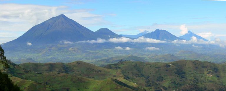 Photo: Byekwaso Blasio / CC BY-SA 4.0

7 Days Mount Mgahinga Gorillas, Golden Monkey and Volcano Hike
by Insight Safari Holidays Verified operator
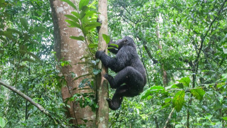

11 Days Uganda Primates Safari
by Tranquil Safaris Verified operator
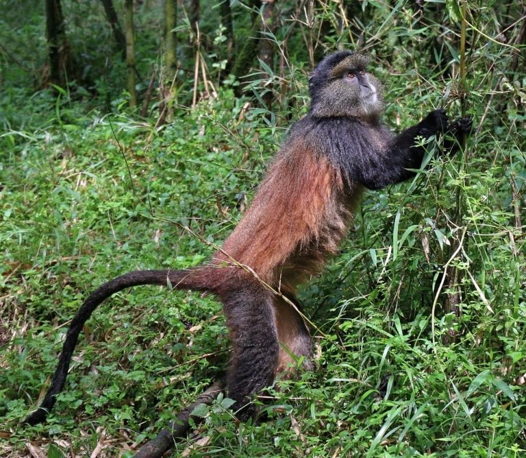 Photo: Charles J. Sharp / CC BY-SA 4.0
4 Days Golden Monkey Trekking in Uganda
by Insight Safari Holidays Verified operator