
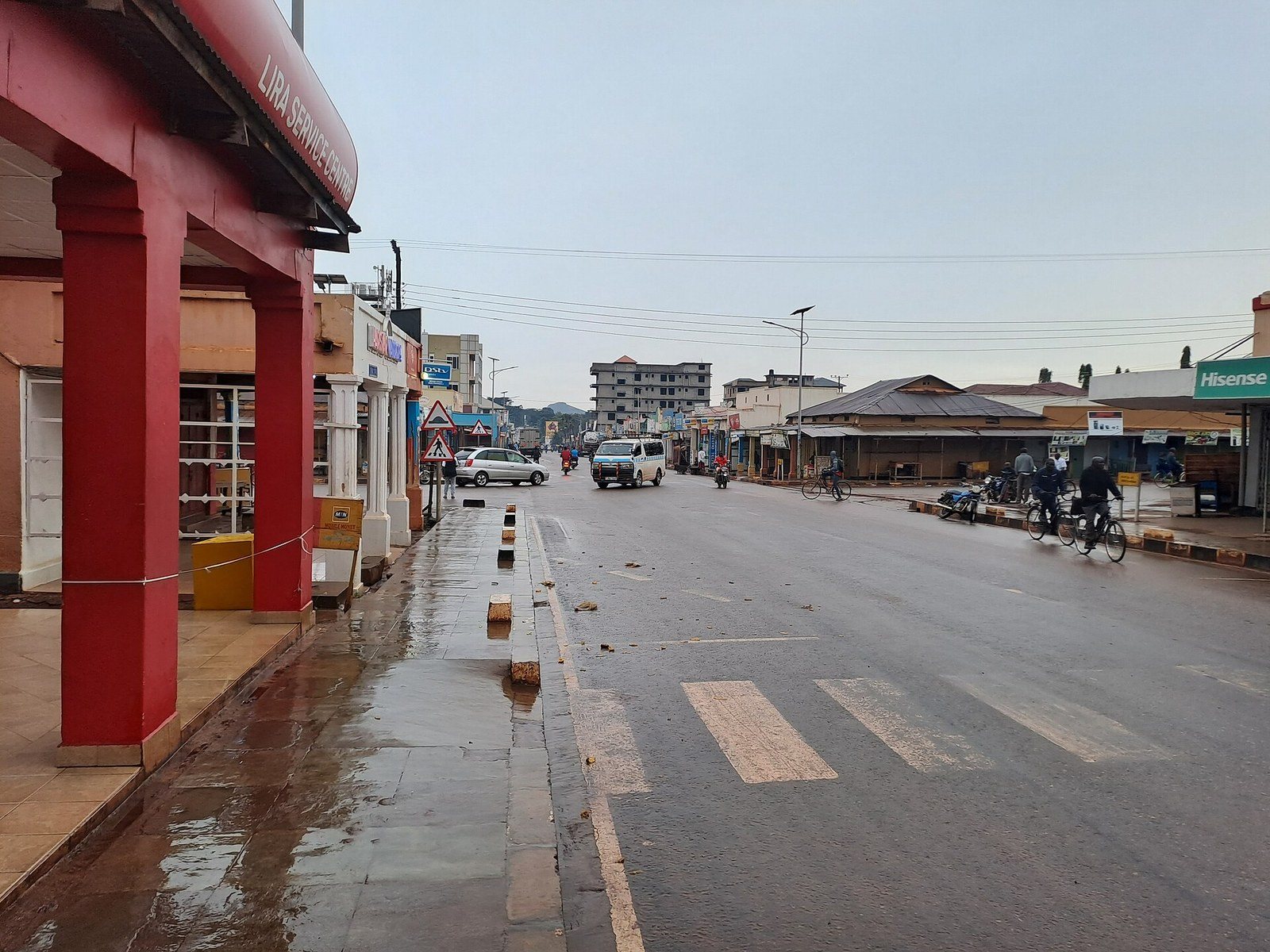
Lira is the commercial centre of Uganda’s Lango sub region and a practical overnight on the road north, with Got Ngetta, the Barlonyo memorial and a large working market all inside half an hour of the centre. Most visitors arrive on a northern Uganda trip aimed at Murchison Falls or Kidepo Valley. The city sits about 337 kilometres up the tarmac from Kampala, on the flat Lango plain east of the Karuma crossing.
Lira as a Stop on a Northern Uganda Trip
Set expectations correctly and Lira works well. Set them wrongly and you will wonder why you stopped.
This is a trading and university city of a little over 246,000 residents at the last national census, which makes it marginally the larger of the north’s two cities on resident count while Gulu pulls in more people by day, and it is busy in the way that a regional commercial hub is busy: lorries, boda stages, hardware shops, sesame and sunflower going through the mills. City status arrived recently, in the same round of promotions that made Gulu one. Lira University is here, so is a regional referral hospital serving several districts, and so are the Mukwano and Meru milling operations that give the surrounding farmland somewhere to sell to.
What it does not have is a tourism industry. No lodge, no guided product, no visitor centre, and only a handful of sites that a traveller would recognise as attractions. What it does have is Got Ngetta, which is a genuinely good half day, and Barlonyo, which is the most important thing in the sub region and nothing like a day out.
So the useful question is not whether Lira is worth a week. It is whether Lira or somewhere else should be your break on the run north, and that depends on your route. Coming up the Kampala to Gulu highway and heading for Murchison’s northern gates or for Kitgum, Gulu is the natural stop. Coming up the eastern side through Soroti, or heading for Kidepo by the Kotido road, Lira is the one. It is also the better choice if you want a quiet evening, since it is smaller and less geared to visiting organisations than Gulu is.
Got Ngetta Hiking Tours and the Rock Above Lira
The best few hours in Lira are spent on a rock. Got Ngetta stands roughly eight to ten kilometres out on the Kitgum road, a dark granite outcrop rising to about 4,500 feet, and the walk up it is the closest thing the city has to a signature activity.
The name comes from Luo and carries the sense of a rock that broke away, which fits the shape of it: slabs and fragments piled against the main dome. Local tradition holds that the ancestors of the Langi, Acholi, Iteso, Kumam, Karimojong and Japadhola all lived together around this hill before they separated, which makes Got Ngetta a place of shared origin across half of northern and eastern Uganda rather than a Lango site alone. Whether you take the story literally or not, it is the reason the hill matters to people here, and it is worth knowing before you climb it.
The climb itself is short and steep rather than long, an hour or so of scrambling on rock and worn path, and it is done comfortably in trainers. A troop of vervet monkeys lives on it and is usually visible. There are birds and butterflies, and there are snakes, so watch where you put your hands on the upper slabs. From the top the view runs across the Lango plain with the Acholi and Teso country beyond, and on a clear morning it is the best thing you will see between Kampala and Kidepo.
Go early. The rock holds heat and by eleven the exposed slabs are unpleasant. A local guide is easy to arrange at the base and worth taking, both because the paths are unmarked and because Comboni College and a mission sit at the foot of the hill and walking through without a word to anybody is the wrong way to do it.
Barlonyo Memorial Site Tours and the Etiquette They Need
Twenty six kilometres north of the city, in Agweng, there is a monument and a mass grave.
On the evening of 21 February, rebels of the Lord’s Resistance Army attacked the displaced persons camp at Barlonyo. Thousands of people from the surrounding countryside were living there because living in their villages was not survivable. The attackers came at around five in the afternoon, set the huts alight and killed people as they came out. It was over in a few hours. The monument at the site records 301 names.
The number is disputed and that dispute matters. Community accounts and local council figures put the toll considerably higher, with the burial described as a single grave some seventy metres long holding closer to four hundred people. Families who buried their own that week have never accepted the official figure, and they say so every year.
There is a further thing that almost nothing written about Lira mentions. One LRA commander has been convicted by the International Criminal Court. He was found guilty over attacks on four other displaced persons camps. Barlonyo was investigated and then left out, because prosecutors could not establish his presence there to the standard a trial requires. Legally that is a defensible outcome. For survivors who had spent years being told the court would deal with what happened to them, it was not, and they have been open about it. If you visit Barlonyo, you are visiting a place that carries both the killing and the sense of having been passed over afterwards.
Lira Town Tours on Foot: the Market, Obote Avenue and the Cathedrals
An afternoon on foot covers the centre without difficulty. Lira is flat, compact and easy to walk, and nobody will bother you much.
Lira Main Market is the anchor. It is an everyday produce and goods market rather than a craft market, which is what makes it interesting: sesame, sunflower, cassava, dried fish from Lake Kwania, secondhand clothing, hardware. Go in the morning when it is fullest. Obote Avenue runs through the middle of town and carries most of the shops, banks and cafés, and it is named for the man from this sub region who governed Uganda twice.
Two cathedrals sit at opposite ends of the town’s religious history. The Catholic cathedral, dedicated to the Sacred Heart, is the seat of the Lira diocese. All Saints Cathedral at Boroboro is the Anglican one, out on the edge of town, and the older mission buildings around it are worth the walk. Neither is architecturally grand. Both are busy, which is the point.
For an idle hour there is a golf course, one of a small number upcountry, laid out on the edge of town and open to visitors who ask at the clubhouse. It is not a reason to come to Lira. It is a pleasant way to fill an afternoon if the rain has cancelled the hill.
Karuma Falls Trips and the Nile Crossing West of Lira
An hour west of Lira the tarmac reaches the Victoria Nile at Karuma, and the river there is a long run of white water rather than a single drop, hammering through a rocky channel below the bridge. It is one of the more dramatic pieces of river in Uganda and almost everyone driving north sees it through a car window at fifty kilometres an hour.
You can stop. Parking near the bridge and walking back to look is normal, though the bridge itself is a security point and photographing it or the hydropower works is not welcome, so keep the camera on the water. The falls mark the boundary of Murchison Falls National Park on the northern bank, and the Karuma hydropower station sits just downstream, which is why the area has more uniformed presence than a waterfall usually does.
From Lira the detour is easy: out on the Kamdini road, an hour or so each way, and you can fold it into the drive if you are heading for Murchison or Gulu anyway. It is the only piece of scenery near Lira that people arrive already wanting to see.
Lango Culture Tours, the Otole Dance and the Obote Trail
Lango is Luo speaking, like Acholi to the north, but Langi identity is its own thing and people here will tell you so. The sub region was historically a cattle keeping and farming society, and it has its own cultural institution with a paramount chief, its own dance repertoire and a distinct relationship with the Ugandan state that has run through the whole post independence period.
The dance most visitors hear about is the Otole, a war dance performed in formation with spears and shields, physical and loud and nothing like a hotel floor show when it is done properly. Seeing it depends entirely on timing, since it is performed at cultural events, installations and celebrations rather than on a schedule for visitors. Ask locally rather than booking anything in advance, and be sceptical of an operator who promises a performance on a fixed date.
The other cultural thread is political, and it runs through Apac district to the west. Milton Obote, prime minister and then twice president, was born at Akokoro in Apac and is buried there beside his father and grandfather, on the family land rather than in any national monument. It is a modest grave on a rural homestead and visiting means asking properly, through someone who knows the family or the local council. Lango also produced John Akii Bua, who won Uganda’s first Olympic gold in the four hundred metres hurdles and is buried in the sub region. Neither site is signposted or set up for visitors. Both mean a great deal here.
On the food: malakwang, a sour hibiscus leaf stew usually eaten with sweet potato or with millet bread, is the dish of the sub region and every local restaurant does a version. Atapa, the millet and cassava bread, comes with most things. Ask for both by name and you will get a better meal than the chicken and chips the hotels default to.
Day Trips From Lira to Apac, Dokolo and the Otuke Hills
Lira sits in the middle of a sub region rather than at the edge of one, so short runs out in three directions are easy.
West towards Apac takes you through open farmland to the Lake Kwania shore, where the Victoria Nile widens into a shallow, papyrus fringed lake before it turns for Karuma. Fishing villages line it, the birding along the fringe is good without being famous, and it is the quietest water you will find in central Uganda. South towards Dokolo runs into the swampy country between Kwania and Lake Kyoga, which is the part of Lango that floods and the part that grows the rice.
East and north east the ground finally rises into the Otuke hills, low rocky ridges on the way towards Karamoja. Adwari, with its small falls, is out this way, and it is worth saying plainly that it is a couple of hours from the city rather than the short hop that several web pages describe. There is no set up for visitors at any of these places. You go with a driver, you ask at the trading centre, and you take what the day gives you.
Lira on the Road to Kidepo Valley and Murchison Falls Safaris
For most people this is why Lira is on the itinerary at all, and it is worth being precise about what it saves you.
For a Kidepo safari driven overland, the eastern route runs Kampala to Karuma to Lira to Kotido to Kaabong to Kidepo. The whole thing is around 705 kilometres and roughly twelve hours of driving, which nobody sensible does in a day, so Lira becomes the overnight at about the halfway mark. From Lira onward you are looking at eight to nine hours to the park on a surface that turns from old tarmac to murram and stays that way. Our guide to Kidepo Valley National Park covers what waits at the other end.
The Karamoja guide covers the country the second half of that drive crosses.
For Murchison Falls National Park, Lira is a slightly awkward base rather than a natural one. Karuma is an hour west and the Chobe and Tangi gates are reachable, but most Murchison itineraries come in from Masindi on the southern side and never come near Lira. Use it if you are already coming down from Kidepo or across from Soroti. Do not route through it specially.
The honest comparison with Gulu: Gulu has more hotels, a bigger choice of food, a functioning airfield and mechanics who can fix a safari vehicle. Lira has a shorter run to the Kotido road and a quieter night. If your next day is Kidepo by the eastern route, sleep in Lira. If it is Murchison, Kitgum or West Nile, sleep in Gulu.
Getting to Lira and What the Roads Are Actually Like
Tarmac the whole way from Kampala, and the drive is genuinely straightforward until you reach the potholed stretch beyond Karuma.
| Route | Time | Surface |
|---|---|---|
| Kampala to Lira | 5 to 7 hours | Tarmac |
| Lira to Karuma | 1 hour | Tarmac |
| Lira to Gulu | 2 hours | Tarmac |
| Lira to Soroti | 2 hours | Tarmac |
| Lira to Kitgum | 3 hours | Mixed |
| Lira to Kidepo | 8 to 9 hours | Mixed |
Buses run daily from Kampala, leaving from the Namayiba terminal and the parks around Ben Kiwanuka Street, with several operators on the route and morning departures the ones to take. The ride is five to seven hours and is exactly as comfortable as a Ugandan upcountry coach sounds. A private vehicle with a driver does it faster and costs a different order of money. Experienced drivers on this route add about a quarter to any published time and aim to be off the road by six, which is sound advice for the whole of northern Uganda.
One thing to check before you commit to the route. The Karuma bridge carries every vehicle heading north on this highway, and it has been fully closed for repair work more than once, most recently for several weeks while expansion joints were installed. It is open now. A replacement bridge has since been contracted to a Japanese firm under Japanese funding, with civil works due to start beside the existing structure, so expect heavy plant and construction traffic at the crossing and the possibility of fresh restrictions while it goes up. When the bridge is closed, official detours send Lira traffic the long way round through Soroti or across the ferry at Masindi Port, which turns a six hour drive into a very long day. Ask your operator or check Ugandan road authority notices in the week before you travel.
Lira has an airfield about a kilometre and a half from town. There is no scheduled service on it and there has not been for years, so charter is the only option and it is rarely worth arranging. Advice you will find online suggesting you fly to Gulu and transfer by road does not work either, for the same reason. Within the city, boda boda is how everybody moves, and the centre is small enough to walk.
Where to Stay in Lira and the Best Time for a Northern Trip
Hotels in Lira are business hotels, built for traders, staff of organisations and people attending workshops. That is a lower ceiling than a safari town and a much better floor: rooms are clean, water runs, generators come on, and the price is a fraction of what the same standard costs in the south.
The better known properties cluster around the town centre and on the main roads in, and the ones with a pool and a proper restaurant sit at the top of the local range. Below them is a long tail of guesthouses that are perfectly adequate for one night and not much fun for three. Book ahead only if something is on in town, since conferences and political events fill the place with no warning.
Frequently Asked Questions About Lira Trips
Is Lira safe to visit?
Yes. The LRA left northern Uganda two decades ago and has not returned, the camps closed long ago, and Lira today has the ordinary risks of any mid sized African city and no unusual ones. Petty theft in the market and around the bus park is the realistic concern. Take the normal precautions, avoid walking unlit streets late, and agree a boda fare before you get on. The one piece of advice specific to the north is about roads rather than crime: do not drive after dark, because unlit lorries, livestock and unmarked humps make night driving on the highway genuinely dangerous.
How long should I give Lira?
One night for most people, two if you are visiting Barlonyo properly. One night gets you an evening meal, a walk through the market and a dawn climb of Got Ngetta before you drive on. Two nights lets you take the morning at Barlonyo without rushing it, which is the only respectful way to do that visit, and still leaves an afternoon for the town. Three nights is more than the city supports unless you have a reason of your own to be here.
What does a stop in Lira cost?
Less than almost anywhere else on a Uganda itinerary. A bus seat from Kampala runs somewhere around ten to fifteen dollars depending on the operator, and a private vehicle with a driver for the same run is a different order of expense that most people fold into a wider quote. The better hotels in town charge roughly twenty to thirty dollars a night with breakfast, mid range places closer to fifteen, and simple guesthouses well under ten. A driver with a vehicle for a day taking in Got Ngetta, Barlonyo and Karuma usually lands between fifty and a hundred depending on how far you go. Entry to Barlonyo is free, though leaving something with the caretaker is expected and correct. Small community managed sites set their own rates, so confirm with your operator before you budget.
Can I visit Barlonyo on my own, and should I?
You can, and many people do, but it is better arranged than stumbled upon. The site is gated and a caretaker holds the key, so going through a driver or a Lira contact means somebody is expecting you rather than being fetched from his garden. On whether you should: this is not a sight and treating it as one is the mistake to avoid. If you have a reason to understand what happened in this sub region, go, behave as you would at any burial ground, and give the visit the morning it deserves. If you are looking for something to fill an hour, go up the hill instead.
Do people speak English in Lira, and is Luganda any use?
English is widely spoken, particularly among younger people and in every hotel, shop and office you will deal with. The first language is Lango, a Luo language related to Acholi and unrelated to Luganda. Trying Luganda here lands roughly the way it does anywhere in the north, which is to say poorly, since it reads as the language of the south being carried up the road. Learn a greeting in Lango instead. Apwoyo, for thank you and also used in greeting, works across the Luo speaking north and is always well received.
Is Lira a better base than Gulu or Soroti?
It depends entirely on tomorrow’s drive. For Kidepo by the eastern route through Kotido and Kaabong, Lira is the right stop and saves you real hours. For Murchison Falls, Kitgum or West Nile, Gulu is better placed and has more of everything. For a run up the eastern side from Mbale or Mount Elgon, Soroti is the natural break and Lira comes after it. Lira also wins on quiet: it is smaller than Gulu, has far less of an organisation and conference crowd, and you will sleep better.
Can I drive Lira to Kidepo in one day, or do I need another stop?
In one day, yes, in the dry season, if you leave before six and accept that you will arrive tired. Eight to nine hours is the realistic figure and the second half is murram, so any rain adds to it substantially and a puncture or a washed crossing can add hours more. Drivers who know the route treat Kotido as the safety valve: if you are behind schedule by early afternoon, stop there rather than push on towards Kaabong in fading light. Plenty of people prefer to split it deliberately, taking Moroto or Kotido as a second night, which also means the Karamoja leg gets seen in daylight instead of being driven through. In the wet months, do not attempt it in one go.
Uganda Safaris works with Ugandan operators who run the north properly, with drivers who know the state of the Kotido road this month rather than last season, guides who can arrange a Barlonyo visit through the people who look after the site, and vehicles built for the murram past Lira rather than the highway up to it.
No listing on the site overnights here. If the overland drive described above sounds like more than you want, a three day Kidepo wildlife safari flies in and out instead.
Compare what each operator includes, and ask directly for help fitting Lira into a route that also takes in Kidepo Valley or Murchison Falls.
4 Places to Visit in This Area
Individual sites within reach of here, each with its own guide. Some are written up because the name circulates and the place does not, which is worth knowing before you plan a drive around one.
No operator on the marketplace currently lists a safari to Lira.
See every Uganda safari