
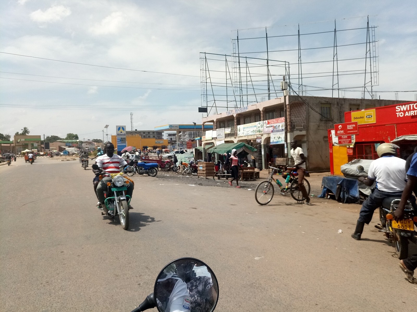
Arua is the commercial capital of the West Nile and the base for everything in Uganda’s far northwest, from Ajai Wildlife Reserve to the waterfalls on the Enyau. Most visitors arrive on a West Nile trip built around the reserve, the river and the culture rather than around big game. Uganda’s most isolated city of any size sits roughly 500 km from Kampala, close to two international borders.
Arua as a Base for a West Nile Trip
Nobody ends up in Arua by accident. It is a full day’s drive from Kampala across the Nile and then some, and the first question any honest guide has to answer is whether that is justified.
Here is the answer. If you want a park, no. The West Nile has no Bwindi, no Queen Elizabeth, and Ajai is a reserve under reconstruction rather than a safari destination. If you want a part of Uganda that tourism has barely touched, with four distinct cultures, a river that hardly anyone floats, food you will not get in Kampala and a city that feels nothing like the south, then yes, and the drive is the price.
Arua itself is a proper city. The last national census put the population of the city area at around 384,000, though you will see figures from 70,000 to 616,000 online depending on whether a page is quoting the old municipality, the city or the district, and none of them says which. It has a regional referral hospital, a university at Muni, banks, a mall, tarmac streets and an airfield with scheduled flights. On the map it looks like the end of the road. On the ground it is a hub, because everything moving between Uganda, the Democratic Republic of Congo and South Sudan passes through it.
The name tells you something. It comes from the Lugbara word for prison, because the colonial administration kept a detention post on Arua Hill, and the town grew up around it. The Lugbara are the largest group here, with Madi, Kakwa and Alur communities across the wider sub region, and none of them has any linguistic relationship to the Bantu languages of southern Uganda. This is a different country from Kampala in every way that matters except the passport.
Two things visitors meet within a day and should know about beforehand. The first is the refugee population. The West Nile hosts one of the largest refugee communities anywhere in Africa, most of it South Sudanese, in settlements at Rhino Camp, Imvepi and Omugo within a couple of hours of the city. Rhino Camp alone holds well over a hundred thousand people. These are not camps behind fences; they are settlements with plots, markets and schools, woven into the local economy, and you will see the aid agency vehicles in Arua every day. They are also not a sightseeing destination, and treating them as one is the wrong instinct. If you have a professional reason to visit, that goes through the Office of the Prime Minister and the agency running the zone, not through a tour operator.
The second is Ombaci. Four kilometres northwest of the city, at the Catholic mission and St Joseph’s College, soldiers of the national army killed close to a hundred civilians who had taken shelter there on 24 June 1981, in the chaotic period after Amin’s fall. Three mass graves are on the mission grounds and survivors hold a memorial there each year on the anniversary. There is no visitor programme and no signage. If you want to go, arrange it through the diocese or a local contact, and go quietly.
Arua City Tours: the Central Market, Arua Hill and Ediofe
An Arua city tour takes a morning and is genuinely worth doing, partly because the city is pleasant and partly because almost no foreign visitor walks it, which changes how you are received.
Arua Central Market is the engine. It is a cross border market as much as a local one, with goods coming in from Ariwara and Aru on the Congolese side and traders working in Lugbara, Kakwa, Swahili and French across the same stall. Produce, dried fish from the Nile, cassava and millet flour, secondhand clothes, hardware, Congolese fabric. Prices are negotiated and foreigners get an opening number with some ambition in it.
Arua Hill rises straight out of the centre and is the walk everyone does. Twenty minutes gets you to the top, where a monument stands and the view runs west across the plain towards the Congo. This is where the colonial detention post stood that gave the city its name. The football stadium at the foot of the hill has become a serious fixture on the Ugandan league calendar and a match day there is the loudest thing in the West Nile.
Ediofe Cathedral, seat of the Arua Catholic diocese, sits a couple of kilometres out and is the larger of the city’s two cathedral churches, with Emmanuel Mvara the Anglican counterpart. Be careful with names here: several travel pages invent a St Patrick’s Cathedral and a West Nile Heritage Museum for Arua. Neither exists. What does exist, and gets missed, is a Hindu temple run by the small West Nile Hindu community, a legacy of the Asian trading families who ran commerce here before the expulsions of the 1970s.
Around the centre sit the golf club, the public library, a mall and a supermarket that anyone who has been upcountry for a fortnight treats as a landmark. The West Nile distillery produces waragi from local cassava. Nightlife is real but modest, clustered in a handful of bars where the music is Congolese as often as Ugandan, which tells you where Arua looks culturally.
Eat local while you are here, because Lugbara food does not travel. Enya, the staple, is a stiff bread of cassava flour often mixed with millet or sorghum, eaten with soups and sauces. Kalo is the millet version. Angara, smoked fish from the Nile, turns up beside most things. Marwa is the local brew, drunk communally through long straws from a shared pot, and being invited to it is a real invitation rather than a performance for visitors. Take it seriously and drink slowly.
Barifa Forest Walks and Birding Tours Inside the City
Barifa Forest birding tours put you in a gazetted forest reserve inside the city limits, which is an unusual thing for any African town to still have.
Barifa, properly the Arua Central Forest Reserve, covers about 236 hectares southeast of Arua Hill and runs towards Mvara and Muni. It was gazetted in 1932 and has survived, just, on the edge of a growing city. Much of it is now plantation rather than natural forest, and encroachment from the surrounding suburbs is constant, which is a live local argument.
For a visitor it works as an early morning walk. Birds are the draw: weavers, kites, vultures, storks, crowned crane on the margins, owls at either end of the day, and a large bat population that moves through at dusk. Tracks run through it and the forest is used by joggers, cyclists and schools, so you will not have it to yourself. There is no gate and no formal entry arrangement. Go with a local guide or with someone from your hotel rather than alone, particularly early or late, for the same common sense reasons that apply to any urban green space.
Cycling has become a thing here. Arua’s flat grid and the tracks through Barifa and out into the surrounding villages make it good riding country, and a couple of local outfits will get you a bike. It is the most enjoyable way to see the outskirts.
Miriadua Falls and the Waterfall Trips Around Arua
Waterfall trips are what the West Nile has instead of a national park, and Miriadua is the pick of them.
Miriadua Falls sits in Maracha, roughly 20 km north of Arua on the River Oluffe, reached off the Koboko highway past Kijomoro. Half an hour in a vehicle, or a boda ride for a few thousand shillings. The river drops over a series of rock steps into pools with trees around them, and the site is managed informally by the local community. There is no ticket office, no signage and no facilities, so bring water and expect to leave something for whoever guides you.
It is a modest waterfall. Anyone arriving from Murchison or Sipi will find it small. What it has is quiet, a good picnic spot and a walk along the river, and going early avoids the weekend crowd from the city.
The Enyau is the river that matters most locally. It rises in the Ezuku Forest Reserve in Vurra, runs through Arua city itself, on through Ayivu and Terego and eventually into the Albert Nile, and it carries a string of smaller falls along the way at Oluko, Olewa, Abairo, Agbinika and Dubu. None of them is a headline sight. Strung together with a local guide they make a good half day of walking through villages that see no tourists at all, which is the real point of the exercise.
Hill country rings the city. Mount Wati stands over Terego and Maracha, Mount Liru over Koboko, with Oce and Erusi further out, and Biku and Curube hills closer in. None needs technical gear; all need a guide, since there are no marked trails and the routes go through farmland. The views from the tops run into Congo and South Sudan on a clear day.
Ajai Wildlife Reserve Safaris and the Return of the Rhino
An Ajai Wildlife Reserve safari is the biggest draw near Arua and the one most often misrepresented, so take the correction first: you cannot see the rhinos.
Ajai covers about 166 square kilometres of wooded savanna and seasonal swamp on the west bank of the Albert Nile in Madi Okollo district, roughly an hour from the city. It was created to protect northern white rhino, held several dozen of them, and lost every one to the poaching that followed the political collapse of the 1970s. Uganda’s last wild rhino anywhere was shot in 1983.
What is happening now is a restocking programme. Kob, buffalo, zebra and a dozen Nubian giraffe have gone in, and then four southern white rhinos were driven up from the breeding herd at Ziwa, the first movement of rhino between protected areas inside Uganda. Sixteen more are planned. The four are in a fenced enclosure under daily monitoring while they settle, which is standard practice and takes as long as it takes.
No rhino viewing or tracking activity is on sale. The wildlife authority does not list Ajai as a rhino tracking site and there is no booking process, no schedule and no gate keeping visitor hours. Some operator pages say otherwise and one publishes a permit price for an activity that does not exist. If you want to see rhino on foot in Uganda, the ranch at Ziwa on the Gulu highway is the place that actually runs it.
What you can do at Ajai is walk with an armed ranger, arranged in advance through the wildlife authority or a local operator, and look for sitatunga in the swamp, Uganda kob, warthog, bushbuck, hippo and crocodile along the river, and a long bird list including shoebill on the wetland edges. There is no lodge, no visitor centre and no shop. The access road changes character completely with the season, so the same call that books your ranger should ask about the road. Come for a reserve being put back together and you will find it interesting. Come for rhinos and you will be disappointed for reasons nobody told you about in advance.
Koboko and Lodonga: Day Trips North of Arua
The day trips north of Arua run up the tarmac towards South Sudan and take in the two sites people most often ask about.
Koboko, about 70 km up, is Kakwa country and it is where Idi Amin’s family came from. He is buried in Saudi Arabia, not here, and there is no monument, no museum and no site to visit. What there is, is a town that carries the association and has complicated feelings about it, and locals who will talk about it with more care than any book if you are not crass about asking. Mount Liru rises behind the town and is a decent half day climb with a guide.
Lodonga, over in Yumbe, holds the Marian basilica and is the principal Catholic pilgrimage site in the West Nile, drawing large crowds on its feast days. It is a working shrine rather than a tourist attraction, and outside pilgrimage season it is a quiet compound with a long history of missionary presence in the region behind it.
The Alikua pyramid at Ofude is the oddity of the district and almost nothing published about it is reliable. It is a stone structure of uncertain age and origin that local tradition ties to clan history, and it appears on exactly two of the pages that come up when you search for things to do here. Go with someone local who knows the way, keep your expectations modest, and enjoy the fact that you are looking at something that has never been properly studied.
Borderlands, a rural crafts centre in the district, works with local producers on basketry, textiles and pottery, and is the most reliable place to buy something made in the West Nile rather than trucked up from Kampala.
Rhino Camp, Obongi and Boat Trips on the Albert Nile
Albert Nile boat trips are the most underused thing in the West Nile. The river runs the entire eastern edge of the sub region and almost nobody puts a tourist on it.
Rhino Camp, a riverside settlement southeast of Arua, is the usual access point and gives its name to the refugee settlement nearby. The Lopalopa fish market there is a working landing site rather than an attraction, busiest at dawn, and boats can be arranged informally with fishermen. Eripak, further along, is a small riverside resort that functions as the closest thing the district has to a lakeside day out.
What the river offers is hippo, crocodile, waterbirds in numbers, papyrus margins holding shoebill on a good day, and a view of a stretch of the Nile that no commercial boat operator works. What it does not offer is safety equipment, so bring your own judgment: agree the boat, look at it before you get in, and do not go out in wind.
North of there the river is crossed by ferries rather than bridges. The Laropi crossing links Moyo to Adjumani and the Obongi crossing works the same stretch, both government run, both free, both taking a quarter of an hour on the water and rather longer loading. They break down periodically and services get suspended, so anyone routing through that way should check before committing. Zoka Forest, over in Adjumani, is the only substantial natural forest left in the region and is reached from that side.
Murchison Falls Safaris From the West Nile Side
A Murchison Falls safari from Arua approaches the park from the northwest, and that direction has an advantage worth knowing about.
Arua to Pakwach is about 126 km through Nebbi, roughly two hours on tarmac. From Pakwach the Arua to Gulu road runs east along the park’s northern boundary, with Tangi gate about an hour further on and Wankar near Purongo beyond it. Three to three and a half hours from the city puts you inside the northern sector.
That northern sector is where the game is. The Buligi tracks between the Victoria Nile and the Albert delta carry Rothschild’s giraffe in numbers you will not see anywhere else in Uganda, along with elephant, buffalo, Jackson’s hartebeest, Uganda kob and a reasonable chance of lion early in the morning. Coming up from Masindi means crossing the river at Paraa by ferry to reach that grassland. Coming from Arua, you are already on the right bank.
The launch trip upriver to the base of the falls is the fixed point of any visit, with hippo and crocodile the whole way, and the run downstream towards the delta carrying the better chance of shoebill. The top of the falls is on the southern side and involves the ferry if you came in from the north. Park entry is charged per person for each twenty four hours and the figures are in the questions below.
The other way to use this is as the last leg of a loop. Kampala to Murchison, two nights in the park, out through Tangi and on to Arua, back down the Pakwach road. That makes the West Nile drive part of the trip rather than a separate expedition, and it is how the better operators build it.
Crossing the Border From Arua: What Is Actually Possible
Arua sits close enough to two international borders that every guide mentions them and none explains them, so here is the practical position, reported straight.
Vurra is the crossing into the Democratic Republic of Congo, about 19 km west of the city, leading towards Ariwara and Aru in Ituri province. Oraba, roughly 92 km north past Koboko, is the crossing into South Sudan at Kaya. Both are working commercial posts carrying trade, fuel and freight. Neither is a tourist route and there is nothing on either side built for visitors.
Foreign offices in the United Kingdom, the United States, Canada and Australia all advise against travel to South Sudan, and against travel to eastern Democratic Republic of Congo including Ituri and the Kivus. That advice is about armed groups, kidnapping and general instability, and it is not a formality. Ordinary travel insurance is void where it applies. This is the part the travel pages that describe the borders as atmospheric leave out.
There is a health dimension too and it should be stated calmly. An outbreak of Bundibugyo virus disease, a form of Ebola, has been running in eastern Democratic Republic of Congo since it was identified in Ituri, and it has grown a long way beyond where it started. It now reaches six provinces, Ituri, North Kivu, South Kivu, Bas Uele, Haut Uele and Tshopo, across roughly sixty health zones, with Ituri worst affected. Several thousand cases have been confirmed and close to half of those infected have died. The World Health Organization classed it a public health emergency of international concern and its emergency committee has kept that classification in place. Uganda’s own outbreak was smaller and is finished: twenty cases and two deaths, traced back across the border and contained without a wider epidemic, declared over in late August once the forty two day clear period had passed. Screening continues at airports and official land crossings on both sides, Vurra among them, and a case reported in early September had travelled through several Congolese provinces and across into Rwanda and Uganda, so the checks are not a formality. WHO advises against restricting travel to or trade with the affected countries, and none of this makes Arua a dangerous place to visit. It does mean the Congolese border is not somewhere to cross casually, that you should check the current position with your own foreign office and the World Health Organization before you travel, and that you should not rely on anything written more than a few weeks ago, this page included.
Within Uganda itself, the West Nile is not subject to any advisory of that kind. Arua, Koboko, Maracha, Terego and Madi Okollo are ordinary places to travel in, and the caution applies to what is on the far side of the line rather than to the sub region you are standing in.
Getting to Arua by Road and Air
The road from Kampala runs about 500 km and there are two ways to do it, which no ranking page bothers to distinguish.
The standard route goes north on the Gulu highway through Luweero and Nakasongola, crosses the Victoria Nile at Karuma, turns northwest at Olwiyo, crosses the Albert Nile again at Pakwach, then runs through Nebbi to Arua. Tarmac the whole way. Seven hours is the optimistic figure and eight to nine is honest once you add Kampala’s morning traffic, fuel stops and the freight convoys heading for Juba. It is a long day and it should be a whole day. Do not attempt any part of it after dark.
The other route goes via Masindi, through Murchison Falls National Park, across the Paraa ferry and out to Pakwach. It is shorter on paper and slower in practice, it requires park entry fees, and the ferry runs to a timetable. It only makes sense if you are visiting the park anyway, in which case it is the obvious way to combine the two.
Buses run from Kampala daily and take most of a day, with several operators working the route. It is cheap and it is long. Minibuses cover the shorter hops within the sub region.
Flying removes the whole problem. Scheduled services run between Entebbe and Arua’s airfield several days a week, operated by more than one small carrier, in aircraft seating around a dozen people, and the flight takes a little over an hour against a full day on the road. Fares are what you would expect for a twelve seater on a thin route, and the figures are below. Schedules on routes like this change, so book through an agent who will tell you when they do. Hiring a vehicle and driver at the Arua end is straightforward and is what most people who fly up end up doing.
Within the city, boda boda is the default and a hop costs almost nothing. For the sites outside it, a car with a driver for the day is the sensible answer and every hotel arranges them. Fuel is reliable in Arua and much less so in the smaller towns, so fill up before heading for Ajai, Lodonga or the river.
Where to Stay in Arua and the Best Time for a West Nile Trip
Arua’s hotels exist for traders, government and the aid sector rather than tourists, which keeps standards better than the visitor numbers would suggest and keeps prices reasonable.
The Heritage properties are the established names, split between a busier one with a health club and entertainment and a quieter one with gardens and a rooftop. Golden Courts and Desert Breeze sit in the same bracket and both get consistent reviews for clean, spacious rooms and helpful staff. Below them are numerous small guesthouses around the centre. One practical warning that comes up repeatedly and appears in no guide: the mains electricity in Arua goes off routinely, most hotels run a generator, and several of them switch that generator off between midnight and six in the morning. Charge everything in the evening and expect a warm room at four in the morning. Ask about the generator hours when you book if that matters to you.
Ajai has no accommodation at all, so anyone visiting the reserve sleeps in Arua and treats it as a day out. The district has been encouraging communities near the reserve to build hospitality businesses on the strength of the rhino programme, which tells you both that the intent is real and that it has not happened yet.
On timing, the West Nile sits in a single long wet season rather than the two rains pattern of the south. Rain runs from around April through October, peaking in August and September, and the dry season covers roughly November to March. That dry stretch is hotter and dustier than anything in southern Uganda, with afternoons well into the thirties and a harmattan haze off the Sahel at the turn of the year.
For practical purposes the dry months are much better for driving, because the road into Ajai and the tracks to the falls and hills are murram and turn difficult when wet. The Ajai swamp floods seasonally and the reserve becomes partly inaccessible at the height of the rains, which is the single biggest seasonal constraint on a West Nile trip. If the reserve is the reason you are going, come in the dry. If the city and the culture are the reason, the rains cost you very little beyond an occasional afternoon indoors, and the country is far greener.
Frequently Asked Questions About Visiting Arua
Can I see the rhinos at Ajai Wildlife Reserve?
No. Four southern white rhinos have been moved to Ajai from the breeding herd at Ziwa and are being held in a fenced enclosure under daily monitoring while they acclimatise, with sixteen more planned in a second phase. The wildlife authority sells no rhino viewing or tracking activity at Ajai, the reserve does not appear as a rhino tracking site in the conservation tariff, and there is no booking process or schedule for one. Several travel pages claim otherwise and one even quotes a permit price. They are ahead of the facts. For rhino on foot in Uganda, go to Ziwa on the Gulu highway.
Is Arua safe to visit?
Yes. Arua has the ordinary urban risks of any Ugandan city, mainly opportunistic theft around the market and the transport stages, and visitors are not targeted. No foreign office advises against travel to the West Nile sub region itself. What they do advise against is travel into South Sudan and into eastern Democratic Republic of Congo, both of which start within an hour or two of the city, so the caution applies to crossing rather than to staying. The genuine risks on a trip here are the long highway drive, night driving, which you should simply not do, and malaria, which is present year round.
Should I be worried about the Ebola outbreak across the border?
Worried, no. Informed, yes. An outbreak of Bundibugyo virus disease, one of the Ebola family, has been running in eastern Democratic Republic of Congo and has spread well beyond Ituri and the Kivus into three further provinces, with several thousand confirmed cases and a death rate close to half. It remains a public health emergency of international concern. Uganda’s own outbreak was a much smaller affair, twenty cases and two deaths that were traced and contained, and it was declared over in late August after the standard clear period. Screening operates at land crossings and airports. For a visitor staying on the Ugandan side the practical position is straightforward: do not cross into Congo, expect a temperature check or a questionnaire, and check the current position with the World Health Organization and your own foreign office shortly before you travel, because this is the part of the page most likely to be out of date by the time you read it.
What does it cost to reach Arua and stay a few nights?
Flying is the expensive convenience. Scheduled seats between Entebbe and Arua run around two hundred dollars one way and a little under four hundred return, which buys you a little over an hour instead of a full day on the road. A bus seat from Kampala is a fraction of that and takes most of a day. Hotel rooms at the better properties in town sit roughly in the forty to eighty dollar range with breakfast, mid range places around twenty five, and simple guesthouses well under fifteen. A car with a driver for a day of sites outside the city usually runs between fifty and a hundred. Entry to Ajai is the general wildlife reserve band, which has been around ten dollars for a foreign non resident on a twenty four hour ticket. Rates move, so confirm before budgeting.
How long is the drive from Kampala, honestly?
Eight to nine hours door to door, and anyone quoting six is describing a map rather than a road. It is about 500 km on tarmac through Karuma, Olwiyo, Pakwach and Nebbi, and the distance is not the problem. Getting out of Kampala, the freight traffic heading for Juba, fuel stops and the fact that the last stretch is genuinely tiring all add up. Leave before six in the morning, plan to arrive in daylight, and treat it as the day’s activity rather than something you slot in around others. If that sounds unappealing, fly.
Can I visit a refugee settlement near Arua?
Not as a visitor, and the reason matters. The settlements at Rhino Camp, Imvepi and Omugo hold well over a hundred thousand people between them, mostly South Sudanese, and they are residential communities with plots, markets and schools rather than places with a visitor programme. Access for any purpose goes through the Office of the Prime Minister and the agency managing the zone, and it is granted for professional reasons rather than curiosity. Turning up to look at people living through displacement is not something any reputable operator will arrange. If you want to understand the refugee situation here, talk to people in Arua, where much of the local economy runs through it.
What are the park entry charges if I carry on to Murchison Falls?
Under the most recently published wildlife authority tariff, a foreign non resident pays around forty five dollars per person for each twenty four hours at Murchison Falls, with lower bands for foreign residents and East African citizens and reduced rates for children. Launch trips, ranger guided drives and vehicle entry are charged separately on top. The tariff is published in cycles and is not easy to check independently, so treat that as the shape of it and confirm with your operator or the authority before budgeting.
Is there anything to see connected to Idi Amin at Koboko?
No site, no museum, no grave. His family came from the Koboko area and he is buried in Saudi Arabia. What you will find is a town where the association is common knowledge and where opinions about him are a great deal more complicated than anything written outside Uganda. That conversation is worth having if it arises naturally and it is not something to go hunting for with a notebook. Mount Liru behind the town is the reason to make the drive.
When is the best time of year for a West Nile trip?
November to March, the dry season, for anything involving driving. The road into Ajai, the tracks to Miriadua and the hill routes are all murram and much easier then, and the Ajai swamp floods during the rains, which can put parts of the reserve out of reach. The trade off is heat: the West Nile is hotter and drier than southern Uganda and afternoons in the dry months push well into the thirties, with a dusty haze at the turn of the year. The wet season from April to October is greener and more comfortable to walk in, and it costs you almost nothing if the city and the culture are what you came for.
Will English get me by, and what should I know about greeting people?
English is widely spoken and you will have no trouble in hotels, with guides or in the market. The first language is Lugbara, with Kakwa, Madi and Alur across the sub region, and none of them relates to Luganda at all, so phrases picked up in Kampala will land oddly. Awadifo, meaning thank you, is the word worth learning. Swahili and French turn up constantly in the market because of the Congolese trade. Greetings matter here more than in the south, so do not open a conversation with a question; ask how someone is first and let the answer finish.
Uganda Safaris works with Ugandan operators who actually run the West Nile, with drivers who know how long the Pakwach road really takes, contacts who can arrange a ranger at Ajai in advance rather than hoping one is free, and current knowledge of which flights are running rather than a schedule copied off an old page. The park at the other end of that road is sold on its own terms, for instance as a Murchison Falls and Nile trip out of Entebbe.
Browse the wider northern Uganda itineraries on the site, compare what each operator includes, and ask an operator directly for help building Arua into a route that also takes in Murchison Falls from the northern side.
10 Places to Visit in This Area
Individual sites within reach of here, each with its own guide. Some are written up because the name circulates and the place does not, which is worth knowing before you plan a drive around one.
No operator on the marketplace currently lists a safari to Arua.
See every Uganda safari