
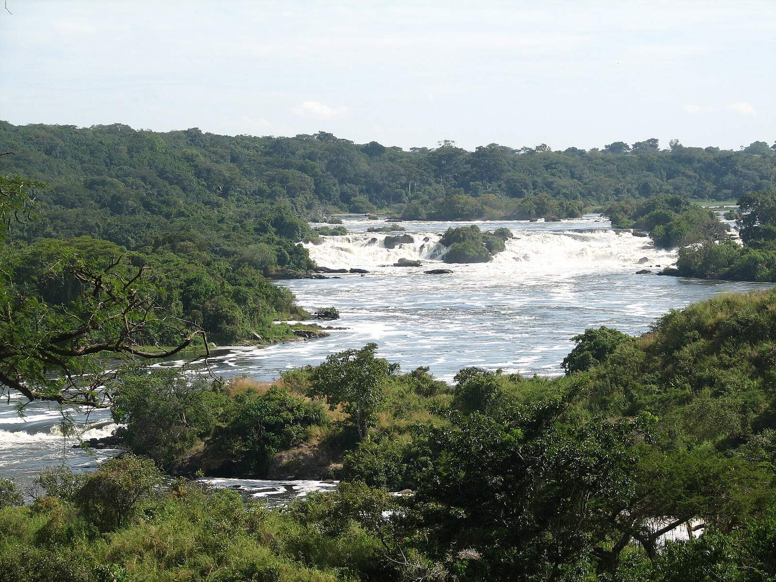
A Karuma Wildlife Reserve safari in the ordinary sense does not exist, because the reserve has no lodges, no tracks laid out for visitors and no booked activities. What people stop for is Karuma Falls, where the Victoria Nile tears through granite beside the Gulu highway. Karuma Wildlife Reserve covers roughly 675 square kilometres of savanna in Kiryandongo District, wrapped around the eastern flank of Murchison Falls National Park.
What a Karuma Wildlife Reserve Safari Actually Amounts To
Most people who read about Karuma will pass through it without noticing. The main road from Kampala to Gulu and on to South Sudan runs straight across the reserve, crosses the Nile at Karuma bridge, and carries on north. That crossing takes about ninety seconds. The stop people make at it lasts ten minutes.
Karuma was set aside as a controlled hunting area in 1962 and gazetted as a wildlife reserve in 1964, with one job: to hold a belt of wild country against the eastern boundary of what was then Uganda’s flagship park, so that animals moving out of it had somewhere to be. That is still its legal purpose. In practice the relationship has inverted. Rather than protecting the country outside the park from wildlife spilling out, the reserve now mostly absorbs pressure pushing in, from settlement, cultivation and grazing along the highway.
There is no reception, no gate selling reserve tickets, no ranger led walk, nowhere to sleep and no marked route. If a page tells you that you can go on a game drive in Karuma Wildlife Reserve, ask who guides it and from where. The wildlife authority runs the reserve as part of the wider Murchison Falls Conservation Area rather than as a place that receives visitors.
So this guide is honest about what the name means. It covers the falls, which are genuinely worth the stop, the reserve behind them, why so little wildlife is left, the generating station that was built inside the boundary, and what a traveller heading north should actually do with the hour they have.
Seeing Karuma Falls Safely on a Northern Uganda Safari Trip
Karuma Falls is not a single drop. The Victoria Nile narrows here and runs for several kilometres over fractured granite in a series of rapids and steps, white the whole way, loud enough that you hear it before you see it. It is a different animal from Murchison Falls forty kilometres downstream, which squeezes the entire river through a gap seven metres wide. Karuma is broad, chaotic and relentless rather than concentrated.
The bridge was built in 1963 and it is still the only crossing on this stretch, which makes it one of the most strategically important pieces of road in the country. Everything moving between Kampala and northern Uganda, and on into South Sudan, goes over it. A replacement has now been contracted, funded by Japan and built by the firm behind the Jinja Nile bridge, with civil works due to begin alongside the old structure. Once the new bridge takes the main load, the old one is to stay in service for light vehicles and motorcycles.
That matters to you for one reason. Photography at Karuma bridge is prohibited, and soldiers are posted there around the clock to make sure of it. This is not a sign nobody enforces. People do get stopped, phones do get taken, and arguing about it goes badly. Not one of the travel pages ranking for this reserve mentions the rule, which is how so many visitors find out the hard way.
What you can do is stop short of the bridge. There is a pull in roughly two hundred metres before the crossing on the southern side where vehicles wait, and from there you get a clear view down onto the white water without being on the structure itself. Ask your driver, who will know exactly where it is. Keep the camera down until you are parked and can see where the soldiers are.
Two claims that circulate deserve correcting. You cannot hike to the top of Karuma Falls, and there is no boat that takes visitors below them. Both appear on one ranking page and neither describes anything that operates. The Nile below Karuma runs through the reserve and the national park with no public access point until you are well inside the park.
Where Karuma Sits on a Murchison Falls Safari Circuit
Three protected areas make up the Murchison Falls Conservation Area: the national park in the middle, Bugungu Wildlife Reserve on the southwestern side against Lake Albert, and Karuma on the eastern side against the highway. Budongo Forest Reserve completes the block to the south. Karuma is the corner of it that almost everybody drives past and almost nobody enters.
The geography is simpler than the pages make it sound. The reserve lies south of the Victoria Nile, gently rolling country crossed by several small watercourses, rising from the river to around 1,300 metres in the south. Vegetation is savanna grassland with elephant grass in the wetter dips and patches of old forest hanging on where fire has not reached, and it becomes properly forested toward the southwest where it meets the Budongo block.
Distances are short and useful to know. Gulu is about seventy kilometres north. Masindi is about a hundred and ten kilometres southwest. Chobe Gate into Murchison Falls National Park sits roughly two kilometres from the bridge, which surprises people who assume Karuma is nowhere near the park. Tangi Gate, the northwestern entrance, is about a hundred and ten kilometres along the road toward Pakwach.
One number to be careful with. Almost every page gives the reserve as 820 square kilometres. The protected area register and the wildlife authority both list 675 square kilometres and then, on the same line, convert that to 82,000 hectares, which is arithmetically wrong. Somebody read the hectares, divided by a hundred, and published 820. It has been copied ever since. Use 675 and treat anything derived from 820 with suspicion.
Wildlife Watching in Karuma Wildlife Reserve and Why So Little Is Left
Karuma shares its species pool with Murchison Falls National Park next door, and animals move between the two in herds as the grazing changes. What the reserve does not have is density, and the reason is a sequence rather than a single event.
Start with what the reserve is. A buffer strip along a trunk road was always going to be the hardest kind of protected area to hold. Then add the road itself, upgraded and busier decade by decade. Then settlement along it, because a highway attracts trading centres and trading centres attract farms. Kiryandongo District also hosts one of Uganda’s largest refugee settlements, a place that has absorbed people from South Sudan and elsewhere over many years and has grown far beyond the seven thousand figure the travel pages still quote. Grazing, charcoal burning and cultivation followed. Then, most recently, the construction corridor for the generating station cut roads, camps and quarries through the middle of it.
None of that is a scandal and none of it is unusual. It is what happens to a reserve with a highway through it and no tourism revenue defending it. The result is that Karuma today functions as habitat corridor rather than as a wildlife viewing area.
What is genuinely here: elephant and buffalo crossing from the park, hippo in the river, waterbuck, Uganda kob, bushbuck and oribi on the grassland, warthog, olive baboon and vervet monkey along the roads, and black and white colobus where the forest patches survive. Leopard are present and almost never seen. Crocodile use the calmer water below the rapids.
Giraffe deserve a note because several pages list them. Murchison’s Nubian giraffe live overwhelmingly north of the Victoria Nile, and Karuma lies south of it. Seeing one from the highway would be a freak sighting and nobody should plan for it.
The Karuma Dam Inside the Reserve and What It Changed for Safari Visitors
This is the largest thing that has happened to Karuma in sixty years and not one travel page ranking for the reserve mentions it.
A 600 megawatt hydroelectric station was built here, inside the reserve boundary, and is now in commercial operation. The engineering is worth a paragraph because it explains what you see and what you do not. A roller compacted concrete dam about twenty metres high and three hundred and twelve metres long crosses the river above the falls. Six intake towers feed six pressure shafts driven through the rock. The station itself is underground, in a cavern roughly two hundred metres long and fifty three metres high, holding six vertical Francis turbines of a hundred megawatts each. Water returns to the river downstream through a tailrace tunnel.
The practical consequence is that a share of the Nile now travels through rock rather than over it. How much difference that makes to the white water you can see from the roadside has never been published in any before and after measurement, and claims in both directions circulate without evidence. What can be said honestly is that the falls still run hard, that the volume is now partly managed rather than purely natural, and that anyone telling you the falls have been destroyed or that nothing has changed is guessing.
For a visitor the visible effects are the access roads, the transmission lines, the construction scars still healing on the reserve side, and a tighter security posture around the whole crossing. That last point connects directly to the photography rule. You are standing beside a bridge and a generating station that the state treats as critical infrastructure. Behave accordingly and nobody will trouble you.
Birding Tours Along the Karuma Stretch of the Nile
Nobody has surveyed Karuma Wildlife Reserve properly, so any bird number you see attached to it was invented or borrowed from the national park. What the site does have is habitat, and the rapids in particular hold birds that flat water does not.
Pied kingfisher work the eddies below the rocks and are constant. Giant kingfisher, much scarcer, use the same water. Red throated bee eaters nest in colonies in sandy banks through this part of the Nile valley and are one of the few birds that make a roadside stop feel like birding rather than waiting. Herons and egrets stand on the exposed granite. Palm nut vultures sit in the Borassus palms. On the grassland behind, the ordinary savanna suite is present but thin.
Serious birders on this route do not stop at Karuma for the birds. They carry on to Budongo, where the Royal Mile at Busingiro is one of the finest lowland forest birding tracks in Africa, or into the park for the Nile delta and its shoebill. Karuma is ten minutes of rapids birding on the way to somewhere better, and there is no shame in treating it that way.
What to Do Instead on the Karuma Safari Road
If Karuma itself gives you ten minutes, the road it sits on gives you a great deal more. This is the fast northern route to Murchison Falls and there is more strung along it than most itineraries use.
Chobe Gate is two kilometres from the bridge, and Chobe Safari Lodge sits on the Nile just inside it, which makes an overnight here a perfectly sensible way to break the drive rather than pushing on to Paraa in the dark. From Chobe the northern bank game drive circuit is open to you the next morning, and that is where Murchison’s giraffe herds, buffalo and lions actually are.
South of Karuma the highway passes the rhino ranch at Ziwa, near Nakasongola, where rhino tracking on foot with rangers is the one place in Uganda you can walk up to a white rhino. It is a natural morning stop on the way north or an afternoon one on the way back.
Southwest, the Masindi road takes you to Budongo Forest and chimpanzee trekking at Kaniyo Pabidi, and on to the escarpment route into the park through Bugungu. Travellers with time often go north on the Karuma road and return on the Masindi one, which turns the drive into a loop rather than a repeat.
Best Time to Visit Karuma Wildlife Reserve on a Safari
The road is tar and the stop is a roadside one, so Karuma is far less season dependent than the reserves reached on murram. You can make this stop any month of the year.
What the season changes is the river and the onward driving. High water after the long rains makes the rapids at their most violent and their loudest, which is when the stop is at its best as a piece of theatre. Low water at the end of the dry season exposes more granite and reads as less dramatic. For wildlife, and for the park you are almost certainly heading into, the dry months from late June to September and from December to February are the ones that matter.
Where to Stay Near Karuma on a Murchison Falls Safari
Nothing inside the reserve. The realistic choices sit on three sides of it.
Chobe Safari Lodge is the closest proper lodge, a short drive from the bridge on the northern bank of the Nile inside the national park, and it is the obvious overnight if you have driven up from Kampala and want to start a game drive early. Karuma trading centre itself has basic guesthouses aimed at truck drivers and traders rather than travellers, and they are fine for a bed and not much more.
Gulu, seventy kilometres north, has the best range of ordinary hotels in the region and is worth a night in its own right. Masindi, a hundred and ten kilometres southwest, is the classic Murchison staging town with several long established hotels and the last dependable supermarket and fuel before the park’s southern gates.
Deeper into the park, Paraa Safari Lodge, Pakuba and the bandas and campsite at Paraa itself all sit two to three hours further on once the park speed limit is taken into account.
Getting to Karuma Wildlife Reserve for Your Safari Trip
Karuma is one of the easiest places in this guide to reach and one of the hardest to actually enter.
By road from Kampala it is roughly 260 kilometres on the Gulu highway, tar the whole way, four to five hours depending on traffic through Luweero and Nakasongola. This is the fastest route into Murchison Falls National Park, which is why so many itineraries use it northbound and the Masindi road southbound.
Public transport works. Buses running from Kampala to Gulu, Arua and the northern towns all cross Karuma bridge and will set you down at the trading centre, and they leave through the day rather than on a fixed timetable. Fares are modest and paid in local currency at the terminal. What buses will not do is get you into the reserve or the park, so plan the onward leg before you step off one.
Four wheel drive is unnecessary for the highway itself and becomes necessary the moment you turn off it toward any of the park gates in wet weather.
Flying skips the road entirely. Scheduled domestic flights from Entebbe serve Chobe, Pakuba and Bugungu airstrips inside the conservation area, and the lodges collect you. If your trip is short and Karuma is only a bridge on the way, this is how to buy back the day.
Karuma Safari Questions Travellers Ask Most
Can you visit Karuma Wildlife Reserve, or is it only the falls?
In practice it is only the falls, and even those are viewed from the public road rather than from inside the reserve. There is no visitor gate, no accommodation, no ranger led activity and no track network open to tourists. The reserve exists as a management unit inside the Murchison Falls Conservation Area rather than as a destination. If an itinerary sells you a Karuma game drive, ask which tracks and whose guides, because the honest version of that line is a photo stop and a transfer.
Why can I not take photographs at Karuma bridge?
The bridge is the only Nile crossing on the main route to northern Uganda and South Sudan, and there is now a large generating station beside it, so the state treats the whole site as critical infrastructure. Soldiers are stationed there permanently and the ban is enforced rather than notional. Stop at the pull in a couple of hundred metres short of the crossing on the southern side, take your pictures of the white water from there if the soldiers are content, and keep the camera down while you are on the bridge itself.
What does it cost to enter Karuma compared with Murchison Falls National Park?
Karuma sits in the wildlife authority’s lower reserve tier. On the published tariff tables that band has been USD 10 per person for foreign non residents and USD 5 for foreign residents, valid for 24 hours, while entry to Murchison Falls National Park is USD 45 for a foreign non resident. Both figures come from the 2024 to 2026 conservation tariff, which names Karuma directly in its lowest entrance band, and neither of them changes on the tariff that takes effect on 1 January 2027. Confirm the figure with the authority or your operator before you budget. In reality almost nobody pays a Karuma reserve fee, because the highway crossing is public road and the fee you will actually pay is the park one at Chobe Gate.
Is Karuma Falls worth stopping for if you are already seeing Murchison Falls?
Yes, and for about ten minutes. They are completely different things. Murchison is a single violent squeeze through a narrow gap that you walk up to and stand over. Karuma is kilometres of broad white rapids that you look down on from a road. Seeing Karuma first actually improves Murchison, because you arrive with a sense of how much water the river is carrying before it reaches the gap. What Karuma is not is a half day.
How far is Karuma from Murchison Falls National Park?
Much closer than people expect. Chobe Gate is about two kilometres from the bridge, so you are all but at the park boundary while you are standing at the falls. Getting to Paraa in the middle of the park is a different matter, because the strictly policed 40 kilometre per hour limit inside the park turns eighty kilometres into a two hour drive. Plan arrival times from the speed limit, not from the map.
Is the Karuma road safe, and is northern Uganda safe to travel?
The Gulu highway is a normal, busy, tarred trunk road and northern Uganda has been settled and open for many years. The realistic hazards are the ordinary ones: heavy trucks, fast overtaking, livestock on the carriageway and driving after dark, which is worth avoiding for the same reasons it is worth avoiding anywhere in the region. Around the bridge itself the only rule that will get you into trouble is the camera one.
Can I combine Karuma with rhino tracking in the same day?
Comfortably. The rhino ranch at Ziwa sits on the same highway roughly halfway between Kampala and Karuma, and tracking on foot with rangers usually takes an hour or two once you are there. A common shape is a morning departure from Kampala, rhinos before lunch, Karuma bridge in the afternoon, and a bed at Chobe or inside the park that evening. That is a long day but a well used one.
Why does everything I read say Karuma is 820 square kilometres?
Because of a single arithmetic slip that has been copied for years. The protected area register lists the reserve at 675 square kilometres and simultaneously states 82,000 hectares, which does not match. Somebody converted the hectares figure and published 820 square kilometres, and every page since has repeated it. The register figure of roughly 675 is the one to use, and the mismatch inside the official record is a good illustration of how thin the documentation on Uganda’s smaller reserves really is.
Uganda Safaris works with Ugandan operators who plan the northern route honestly, which means pricing Karuma as the roadside stop it is, warning you about the camera before you reach the bridge, and putting your game viewing time on the northern bank where the animals are. Browse the Murchison Falls and northern circuit itineraries on the site, ask whether a quoted trip runs up the Karuma road and back through Masindi, and ask an operator directly to build the drive as a loop rather than a there and back.
2 Places to Visit in This Area
Individual sites within reach of here, each with its own guide. Some are written up because the name circulates and the place does not, which is worth knowing before you plan a drive around one.
No operator on the marketplace currently lists a safari to Karuma Wildlife Reserve.
See every Uganda safari