
Volcanic Uganda: Virunga Cones and the Crater Fields
Uganda’s volcanic country: the three Virunga cones at Mgahinga, the Toro Ankole crater fields, and the worn shield of Mount Elgon.
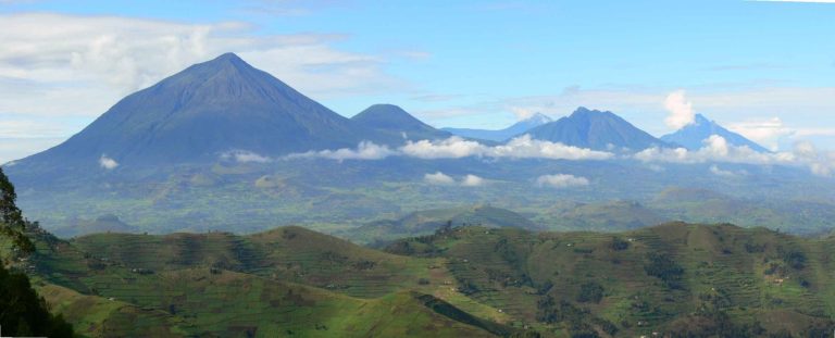
Volcanic country in Uganda takes two shapes. Three steep Virunga cones stand on the southwest border at Mgahinga, all of them climbable in a long day. Further north, hundreds of blast craters lie scattered across the western Rift with no cone at all, many holding water. Nothing in Uganda has erupted in recorded history. The live volcanoes of the chain are across the Congolese border.
Safaris That Include Volcanic Landscape

Volcanic Landscape Guide in Uganda
Volcanic Tours in Uganda: Two Very Different Fire Regions
Volcanic country in Uganda comes in two forms and they look nothing alike. In the far southwest, three steep cones of the Virunga chain stand on the border with Rwanda and the Congo, the shape most people picture when they hear the word volcano. Further north, spread across the floor and shoulders of the western Rift, sit hundreds of blast holes with no cone at all: grass covered tuff rings, maars and craters, many now holding water.
The second kind is the one worth travelling for, because there is very little like it anywhere. And a plain statement first: nothing in Uganda has erupted in recorded history. Every field here is dormant or extinct, and the fire you might actually see at night is across the border.
The Virunga Volcanoes: Uganda's Three Cones on a Climbing Trip
Uganda holds a slice of the Virunga chain at Mgahinga Gorilla National Park, and all three of its peaks can be climbed. Muhabura is the highest and the most straightforward, a relentless uphill with a small crater lake at the top. Sabyinyo is the oldest and most broken, with a jagged summit ridge where Uganda, Rwanda and the Congo meet at a point you can stand on. Gahinga is the smallest and holds a swampy crater.
These are day climbs, steep and hard rather than technical, and each carries its own fee. The detail of routes, altitude and what to carry belongs on our mountain climbing guide. The gorge cut into Sabyinyo's flank sits on our gorge page.
Toro Ankole Crater Field Tours near Fort Portal
The country around Fort Portal is the most concentrated volcanic ground in Uganda and the least obviously volcanic to look at. No black rock, no cone on the skyline. Instead, circular holes in green farmland, some full of water and some dry, with tea and banana planted right to the rim.
Walking the rims is the way to read it. A local guide will point out where the blast rim sits under a maize garden, and how a ridge between two craters is the wall of both. The lakes themselves are covered on our crater lake page, which is where to go for what to do at the water.
Katwe and Kikorongo on a Queen Elizabeth Safari
Inside Queen Elizabeth National Park the crater drive north of Mweya runs through the Katwe and Kikorongo field, and here the shapes are easier to read because the grass is short and the ground is open. Circular rims, nested craters, and a few filled with water salty enough to kill vegetation at the edge.
These were phreatomagmatic blasts, which means rising magma met groundwater and the steam did the work. That is why so many of them are holes rather than mountains. Lake Katwe, at the centre of it, is worked for salt to this day, and the salt gardens are covered on our geological sites guide.
Mount Elgon: the Worn Down Shield Volcano Trek
Elgon is the oldest of the country's big volcanic structures and the most thoroughly ruined. What was once a very large cone has eroded into a broad shield with a caldera at its heart, so the trek to the top is a long walk up an inclined plain rather than a scramble up a peak. Hot springs rise inside the caldera and the flanks are riddled with lava tubes, which our hot springs page and cave page deal with.
See Mount Elgon National Park for routes and Sipi Falls for the waterfalls cutting through the same volcanic beds.
Rocks You Will Not See Elsewhere: the Geology Tour Angle
This is the part that lifts a volcanic trip here above scenery. The Toro Ankole province sits at the northern tip of the western Rift and produced magma so unusual that petrologists named a whole rock family after Ugandan places. A traveller with any geological background will get far more out of the Fort Portal craters knowing that than not.
Nobody has packaged it. There is no Ugandan geopark and no operator selling a volcanic tour by that name. What you do is tell a good local guide what you are interested in and let them take you to rims, quarries and road cuts. The wider picture of rift geology is on our geological sites page.
Is Anything Still Active? What a Volcanic Trip Can Promise
Karamoja's Old Volcanoes on a Northern Safari Route
The far northeast has its own set, much older and much more eroded: Moroto, Napak, Kadam and Toror, standing over the plains as steep isolated mountains. These are the worn cores of volcanoes that stopped erupting long before the western fields started. Napak in particular has produced important fossil beds.
Almost nobody visits them for the geology, because the region is visited for Kidepo and for the people. If you are already driving through Karamoja, it is worth knowing what those shapes on the plain actually are.
Frequently Asked Questions About Uganda Volcanic Tours
What does it cost to climb a Ugandan volcano? The Uganda Wildlife Authority tariff sets Mgahinga volcano climbing at USD 100 for a foreign non resident, excluding park entrance, which is USD 40. The gorge walk in the same park is USD 30 and platform viewing is USD 10. Walking crater rims outside the parks costs whatever the local guide asks, and that is negotiated on the spot.
Which volcano should I climb? Muhabura for the height and the summit crater lake, Sabyinyo for the three country ridge, Gahinga for the shortest day. All three are hard on the legs and none needs technical skill.
Can I see lava in Uganda? No. The active volcanoes are in the Congo, and old lava flows here are rare, weathered and mostly under vegetation.
How do I find the crater fields without a geologist? Base yourself near Fort Portal and walk with a village guide, or take the crater drive in Queen Elizabeth with a driver who knows the circuit. Reading a little before you go changes what you notice.
Are the craters dangerous? Not from eruption. The hazards are ordinary ones: steep unfenced rims, deep water with no shallow edge, and a few craters where gas collects in still air at the bottom.
When is the best time for a volcanic trip? Drier months give firmer tracks and better visibility from the rims, and the summits are clearer early in the morning whatever the season. See our pillar on the best time to visit Uganda.
The operators listed on this site are independent Ugandan companies who build crater walks and volcano climbs into longer routes and quote you directly. We take no bookings and charge you nothing. Send one enquiry through our contact page and compare the replies.