
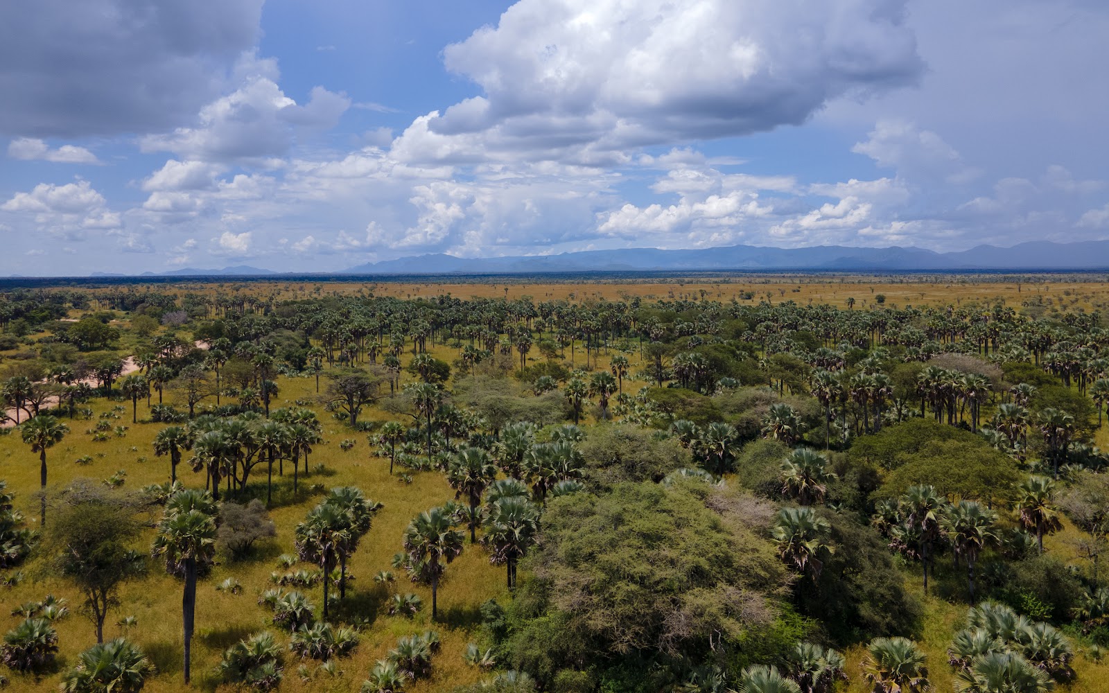
A Bokora Corridor Wildlife Reserve safari is walking country, birding and Karamojong culture rather than a game drive circuit, because the reserve was gazetted as a migration corridor and never developed for tourism. Visits are arranged out of Moroto, usually as part of a wider Karamoja route. Bokora Corridor covers 205,600 hectares of dry plains and inselbergs in Napak district, north eastern Uganda.
What a Bokora Corridor Wildlife Reserve Safari Really Involves
Read the other pages about this reserve and you will come away with a list of leopards, lions, cheetah, giraffe and roan antelope, and a plan to go and see them. Do not book on that basis.
Bokora Corridor is a large, dry, lightly protected block of savanna that has no lodge, no gate lodge circuit, no maintained game drive network and, over much of its area, no usable road at all. It is patrolled by a handful of rangers spread very thin. Cattle graze inside it in large numbers. Wildlife is present and it is genuinely scarce, scattered and shy.
What the reserve does have is space, quiet, some of the best dry country birding in Uganda, one of the country’s more reliable places for ostrich, and a Karamojong cultural setting that no national park can match. The realistic products are a guided walk with a local operator, a night in a fly camp, a birding morning at the swamp and a homestead visit. Take it as that and it is a good day or two. Take it as a safari reserve and it will disappoint you.
The other thing worth knowing up front is administrative. Bokora and Matheniko are now run together by the wildlife authority as a single unit, and that unit sits within a wider conservation area alongside Pian Upe. So when a ranger, a survey report or an operator says Matheniko Bokora, they mean both reserves at once, and much of what applies to one applies to the other.
The Migration Corridor Between Two Karamoja Safari Reserves
The clue is in the name and almost nobody explains it. Bokora was not set aside because it held spectacular game. It was set aside in 1964 to give animals freedom of movement between the Matheniko reserve to the north east and Pian Upe to the south, keeping the two blocks connected instead of stranding their wildlife in separate pockets.
Look at the three together and the design makes sense. Pian Upe covers about 228,700 hectares at the southern end. Bokora runs 205,600 hectares through the middle. Matheniko holds about 158,650 hectares in the north east against the Kenyan border. Together they make a protected block of roughly three and a half thousand square kilometres, the largest continuous stretch of savanna protection in Uganda after Murchison Falls, and it was drawn to work as one system.
Whether it still works as one system is the open question. Corridors only function if animals can actually move through them, and a corridor grazed by thousands of cattle, crossed by livestock trails and patrolled by a skeleton staff moves fewer animals than the map suggests. That is not a reason to write the reserve off. It is the reason the recent renewal of aerial counting across Matheniko Bokora matters, since the last full survey before it was done years ago and nobody has known with any confidence what is in there.
Game Drive Safaris and What You Will Actually See in Bokora
Game drive safaris in Bokora are possible along the tracks that exist, most usably on the eastern side within reach of Moroto and the Moroto to Kotido road. A wildlife authority ranger goes with you, arranged through the Matheniko Bokora office. Beyond those tracks the reserve is not driveable, which is the single most important practical fact about it.
Manage your expectations by species rather than by list. Ostrich are the standout and this is one of the better places in the country to see them, out on the open plain in the early morning. After that come oribi, Bright’s gazelle, bohor reedbuck, dik dik, bush duiker, warthog, olive baboon, vervet and patas monkey. Eland, Uganda kob, topi and hartebeest are all recorded and are seen far less often than the lists imply. Leopard, jackal and spotted hyena are present and nocturnal.
The rarities repeated on every page need a caveat. Lesser kudu and greater kudu are both listed for the Karamoja reserves, and Bokora sits at the extreme western edge of the lesser kudu’s range, so records are scarce and a sighting would be notable rather than expected. Roan antelope belong to Pian Upe. Cheetah are counted in the low teens across the whole conservation area rather than in Bokora alone. Lion have been named on Bokora pages for decades and there is nothing to suggest a resident population.
Early morning is the only time worth driving. The reserve is hot by nine and the animals are gone into cover, and the light for photography goes flat quickly. If you have one shot at it, take the first hour after sunrise on the plains near the swamp.
Birding Safaris at Loporokocho Swamp and the Bokora Thornbush
Birding is the honest reason to come, and it is strong enough to carry a visit on its own. Dry acacia and thornbush is habitat Uganda mostly does not have, so a Bokora birding safari puts species on a Uganda list that are otherwise out of reach without crossing a border.
Loporokocho swamp is the site everyone names and it earns the attention. A seasonal wetland sitting in dry country pulls in waterbirds and everything that comes to drink, and it concentrates activity in a way the surrounding plains do not. Work it early, from the edge, on foot with a guide.
The bird to chase is the Karamoja apalis, a small warbler restricted to whistling thorn acacia across a narrow band of eastern Africa. Survey work across Bokora, Matheniko and Pian Upe has confirmed the species in all three reserves and identified overgrazing and the clearing of whistling thorn as the main threat to it, which ties the bird directly to the cattle problem below. Look for it in the thorn stands rather than from a vehicle.
Around it comes the dry country cast: common ostrich, Jackson’s hornbill, red and yellow barbet, white headed buffalo weaver, fox kestrel, black headed plover, Abyssinian roller, African grey hornbill and a good spread of larks and pipits. Higher ground towards Napak adds montane species including Hartlaub’s turaco, dusky turtle dove, alpine chat and mountain yellow warbler, which is why serious birders climb rather than stay on the plain.
One correction worth making, since it is copied everywhere. A figure of five hundred bird species for Bokora appears on several tour pages and has no survey behind it. The realistic reserve list is a fraction of that. Judge the birding on the quality of the species rather than a total somebody invented.
Walking Safaris and Fly Camping Across the Bokora Corridor
This is the product that suits the reserve, and it is the one almost nobody writes about.
Because much of Bokora cannot be reached by vehicle, the operators who work Karamoja properly run it on foot. A walking safari here means a local guide, several hours a day at walking pace across the plains and thornbush, and camps carried in ahead of you. Donkeys do the portering on the longer routes, which means you walk with a daypack while the camp goes on ahead. Fly camps are simple and comfortable enough: dome tents, cot beds with real bedding, bucket showers heated over a fire.
What you get from walking is not more animals. It is the thing a vehicle takes away. You hear the reserve, you read tracks, the birding improves enormously, and the herders you meet talk to you rather than watching a vehicle pass. Routes take in rock painting sites and places the Karamojong hold as sacred ground, guided by people from the communities that hold them.
These walks run one to three days from Moroto and are booked ahead through a Karamoja based operator rather than arranged at the gate. That matters. The permissions, the ranger, the water and the donkeys all have to be organised, and none of it happens on the day you turn up.
Karamojong Cultural Tours in the Bokora Reserve
The Bokora are one of the Karamojong groups and they give the reserve its name, alongside the Pian in the south, the Matheniko around Moroto and the Upe towards Amudat. Cattle sit at the centre of the whole culture, which is exactly why the reserve looks the way it does and why a cultural visit here is not a decorative add on to the wildlife.
A Karamojong cultural tour takes in a manyatta, the thorn fenced homestead, and covers the cattle economy, the age set system, beadwork, stool carving and the songs and dances that go with the cattle. Homestays with families are offered by the community based operators, usually as part of a walking route, and they are the version of this that is worth doing.
Rock painting sites in the reserve and on its edges are part of the same story. The Karamojong hold particular hills and springs as sacred and access to them is granted by custodians rather than sold, so a visit only works through someone with a relationship there.
Agree photography before you take a picture. Karamoja has been photographed badly by visitors for a long time and people are within their rights to say no.
Cattle, Grazing and the Honest State of the Bokora Corridor
This is the section every other page leaves out, and it will do more to make your trip go well than any species list.
Livestock grazing inside Bokora and Matheniko is heavy and it is pushing wildlife out. The wildlife authority’s acting warden for Matheniko Bokora has said publicly that his staff are regularly criticised by tourists who arrive, having paid, to find the reserve full of cows rather than the animals they came for. He has also put numbers on the enforcement side: something in the order of forty three staff covering all the districts around Matheniko Bokora, with some outposts down to four rangers.
Enforcement is also politically complicated. A presidential statement that herders could graze in conservation areas while a coexistence policy was worked out has left rangers with very little to act on, and the practical result is that grazing continues.
None of that makes the reserve worthless and none of it should be read as a lecture at the Karamojong, who are pastoralists on marginal land in one of the poorest regions in the country and are doing the only thing the land supports. It does mean two things for a visitor. First, do not book Bokora expecting wildlife density, because the honest picture is thin and it is thin for understandable reasons. Second, the parts of a Bokora visit that are genuinely good, the birding, the walking and the cultural side, are not affected by any of this. Build the visit around those.
There is a hopeful counterpoint next door. In Pian Upe, where livestock has been cleared from some sections and security has improved, giraffe have started returning to areas they had left. Whatever works there is what Bokora needs.
Mount Napak and Mount Kadam Trekking on the Bokora Boundary
The reserve is bracketed by two mountains and both are climbable, which gives Bokora a hiking dimension the plains alone would not.
Mount Napak stands at about 2,538 metres on the northern boundary, the eroded remains of a volcano with a distinctive profile visible across much of southern Karamoja. Napak trekking is a day walk from the villages on its flanks, steep in places, with forest patches near the top that hold the montane birds missing from the plain. Guides are arranged locally in Napak district.
Mount Kadam anchors the southern end at 3,063 metres and is the bigger undertaking, two to three days with camping, usually organised from the Pian Upe side or from Moroto. There is no hut system and no fixed portering arrangement, so everything comes with you.
The inselbergs scattered across the reserve itself are the small version, short scrambles for a view over the plain that work well as an evening stop on a walking route.
Security in Karamoja and What It Means for a Bokora Safari
Not one page ranking for this reserve mentions security, which leaves readers to fill the gap with whatever they last heard about Karamoja.
The factual position. Karamoja has a long history of armed cattle raiding, largely ended by a national disarmament campaign in the late two thousands and revived from 2019 as weapons came back across the borders with Kenya and South Sudan. Kotido, Moroto and Nakapiripirit were the worst affected districts. Military and police operations from 2021, followed by a voluntary disarmament and amnesty programme, brought raiding and gun violence down a long way, and military assessments now describe the region as calm with isolated cattle theft rather than organised raiding.
The British foreign office does not advise against travel to Karamoja. It notes an increased security presence across the Karamoja districts because of cattle theft, reports that armed raids and robberies tied to cattle trading have caused deaths, and tells visitors to stay alert, be cautious and avoid travelling at night.
In practice that means the ordinary things. Drive by day and be off the road before dark. Use a Karamoja based operator rather than one working the region from a desk in Kampala. Take the ranger. Check the current position in the week before you travel instead of trusting an advisory page written months ago. The violence has always been about cattle and between communities, not aimed at travellers, and it is at a low ebb compared with the recent past.
Best Time to Visit Bokora Corridor Wildlife Reserve for a Safari
Karamoja runs on a single wet season, unlike the rest of Uganda. Rain builds around April, peaks in April and May, often breaks in June, returns through the second half of the year and fades in November. December to March is the true dry spell, with December the driest month of all. This is the driest corner of the country and rainfall varies enormously across it, from a few hundred millimetres on the eastern plains to well over a thousand on the western edges.
| Months | Rain | Ground | Verdict |
|---|---|---|---|
| Dec to Feb | Very low | Firm | Best |
| Mar | Building | Firm | Good |
| Apr to May | Peak | Soft | Avoid |
| Jun to Jul | Broken | Mixed | Fair |
| Aug to Sep | Steady | Soft | Birding |
| Oct to Nov | Easing | Drying | Good |
December to February is the window if wildlife is any part of your reason for going. Grass is short and burnt back, animals are visible at distance and the tracks that exist stay usable. The costs are heat around 30C on the plains, thick dust, and smoke from grassland burning that flattens photographs.
Birders should think differently. The wet months put water in Loporokocho, bring migrants through and green the thornbush, and a birding visit in October or early November will produce a better list than a dry season one, though the walking is harder and the mornings wetter.
April and May are the months to avoid outright for anything involving a vehicle. The soils here go from firm to bottomless without warning and the tracks that serve the reserve are unsurfaced throughout. Walking routes can still run, and the operators who work on foot sometimes prefer the season, though you should expect to be wet.
Carry a warm layer whatever the month. The plateau sits around a thousand metres and higher, nights cool fast, and anyone camping will want it.
Where to Stay and Getting to Bokora Corridor for Your Safari Trip
There is no lodge, no banda block and no permanent camp inside Bokora. Camping is allowed in designated spots by prior arrangement with the wildlife authority, with rangers providing security and basic ablutions available, and you bring every piece of your own gear including water. Operators running walking routes set up their own fly camps and that is the more comfortable version of the same thing.
Almost everybody bases in Moroto, which is around half an hour to an hour from the reserve’s eastern edge and has the widest choice of beds in Karamoja, from a plain hotel to a guest house run by the regional tour operator. Nakapiripirit and the trading centres along the highway have basic guesthouses. Mbale, four to five hours south, has the region’s best hotels and is far too distant to day trip from.
Getting there is straightforward in the sense that you follow tarmac to Moroto and then turn off. From Kampala the usual run goes east through Jinja and Mbale, then north through Muyembe, Namalu and Nakapiripirit, and honest drive times are eight to ten hours rather than the seven some pages claim. The alternative in heavy rain is north through Soroti and Iriiri, which is longer and holds up better. From Moroto itself the reserve is an hour at most, and the Moroto to Kotido road runs along it.
Take a 4×4 with real clearance and a full tank from Moroto or Mbale, since the trading centres cannot be relied on for fuel. Load offline maps before you lose signal. Above all, contact the Matheniko Bokora wildlife authority office or a Moroto operator before you set off, because there is no ticket window waiting for you and turning up unannounced at a reserve with no infrastructure and forty odd staff covering nine districts is how people end up driving in circles.
On routing, Bokora almost always sits inside a larger trip. The natural shape is Sipi Falls, Pian Upe, Moroto with Matheniko and Bokora either side of it, then north to Kidepo Valley, which runs ten days to a fortnight and is one of the best overland routes in the country. Given a single day in the area, give it to the swamp at dawn and a Karamojong homestead in the afternoon.
Bokora Corridor Safari Questions Travellers Ask Most
What does it cost to visit Bokora Corridor Wildlife Reserve?
The conservation tariff names Bokora directly, alongside Matheniko, Kabwoya, Karuma and the country’s other smaller reserves, in its lowest entrance band. Entry is USD 10 per person for foreign non residents, USD 5 for foreign residents and for visitors from the rest of Africa, and UGX 2,500 for East African citizens, on a ticket valid twenty four hours. That is a third of what the higher reserve band charges and it is worth knowing, because several pages quote the higher figure for Bokora. Vehicles are charged separately and a ranger guide carries a daily fee. Camping is charged per person per night and is cheap. None of these figures appears on the tariff change taking effect on 1 January 2027, so confirm the current rate with the Matheniko Bokora office or your operator before you budget, and carry cash because there is no card facility.
Is Bokora Corridor worth visiting?
For wildlife alone, no. Go to Kidepo Valley, Murchison Falls or Queen Elizabeth. For birding, walking and Karamojong culture on a Karamoja overland route, yes, and it is genuinely good at those. The mistake people make is booking it as a game reserve and arriving to find scarce animals and a lot of cattle. Booked as a day or two of dry country birding and a night in a fly camp, it delivers something no national park in Uganda offers.
Is there anywhere to stay inside the reserve?
No lodge, no bandas, nothing permanent. Camping is possible in designated areas with advance permission from the wildlife authority, with rangers providing security and simple ablutions on site, and you supply all your own gear and water. Operators running walking routes carry in their own fly camps with dome tents, cot beds and bucket showers, which is the more comfortable option. Otherwise, base in Moroto and drive in for the day.
Why is the reserve full of cattle?
Because Karamoja is pastoralist country on marginal land, grazing pressure is intense, enforcement is thin and the political position on grazing inside conservation areas has been ambiguous. The wildlife authority has around forty three staff covering all the districts around Matheniko Bokora, with some outposts down to four rangers, and a presidential statement allowing herders to graze in conservation areas while a coexistence policy was developed has made it harder still to act. Wildlife moves away from where the herds are, which is why sightings are thin and why the reserve is quieter than the maps suggest.
Is Bokora safe to visit?
Yes, with ordinary precautions. Cattle raiding in Karamoja is between communities and not aimed at visitors, and it has fallen a long way since the recent flare up after military operations and a voluntary disarmament and amnesty programme. Major travel advisories do not advise against going. They do advise staying alert, being cautious and not driving after dark, which is sound advice anywhere in rural Uganda. Use an operator who works the region every week and take the wildlife authority ranger.
Can you do a game drive in Bokora?
Only on the eastern side where tracks exist within reach of Moroto and the Kotido road, and only with a ranger. Most of the reserve has no vehicle access at all, which is why the operators who know it run it on foot with donkeys carrying the camp. If your heart is set on driving, do it at first light on the plains near the swamp and treat anything beyond ostrich, oribi and warthog as a good morning.
How many days do you need at Bokora?
One full day covers a dawn birding session at Loporokocho, a short drive and a cultural visit. Two to three days is what the walking routes need, and that is the version worth doing if you want to understand the place rather than tick it. Anyone adding Mount Napak should allow a further day, and Mount Kadam two to three on top of that.
What should you pack?
This is the driest part of Uganda, so sun protection comes first: a real hat, high factor cream, sunglasses and far more water than you think, since there is nowhere to buy any inside the reserve. Add light long sleeves and trousers against thorn and sun, boots that cope with rock and thorn, binoculars, insect repellent, a warm layer for the evening and a dust cover for camera gear. If you are camping, bring everything, including a cooking setup and all your food.
Do you need a guide, or can you go alone?
You need a wildlife authority ranger inside the reserve and you want a local guide on top of that. The ranger is the rule; the local guide is the difference between a day of empty grass and a day that works, because the people who live around Bokora know where the herds are, which stands of whistling thorn hold apalis and which custodians grant access to the sacred sites. Arrange both in advance through the Matheniko Bokora office or a Moroto operator.
Uganda Safaris lists itineraries from Ugandan operators who actually work Karamoja, including Karamojong owned companies running the walking routes and fly camps that suit this reserve far better than a vehicle does. Browse the north eastern circuit trips on the site, ask whoever quotes you whether the Bokora leg is a drive or a walk, and ask an operator directly to fit the reserve into a Karamoja route that matches the season you are travelling in.
No operator on the marketplace currently lists a safari to Bokora Corridor Wildlife Reserve.
See every Uganda safari