
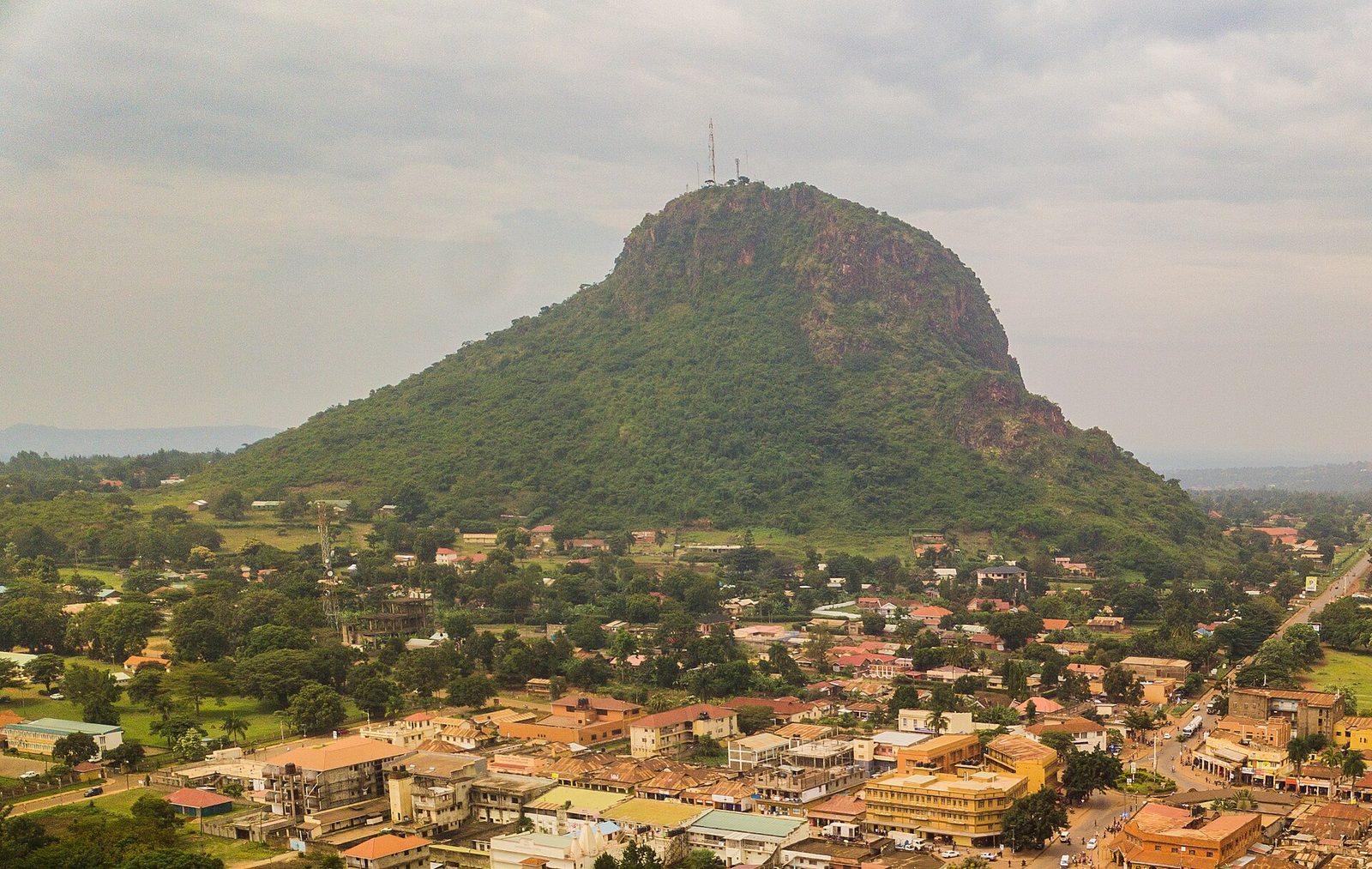
Tororo is the eastern Uganda border town under Tororo Rock, an eroded volcanic plug that visitors climb on a trail fitted with metal ladders near the top. It is a stop rather than a stay, usually taken on the way to or from the Kenyan border at Malaba. The town sits about 209 kilometres east of Kampala, ten kilometres short of the crossing.
Tororo Town Tours and Tororo Rock at a Glance
Tororo is a small town, about 43,000 people by the most recent census, and the rock is why anybody stops. It stands directly over the streets, visible from every road in, and it is the only thing in eastern Uganda that looks like that. Everything else here is industry and transit: three cement plants, a phosphate deposit under the hills, a railway junction and a border ten kilometres away that handles most of the freight moving between Kenya and Uganda.
A Tororo town tour is a short one and the honest answer to “how long do I need” is half a day. Climb the rock in the morning, eat, and drive on. There is no museum, no old quarter worth the name, and no reason to build an itinerary around the place. What there is happens to be genuinely interesting, and almost none of it is described accurately online.
The town has been approved for elevation to a city, alongside a split of the surrounding district into three, and you will see both names in use. The council still runs as a municipality. Either way the place does not feel like a city, and that is not a criticism.
Two other things to fix before going further. Tororo sits at about 1,278 metres, the rock summit at 1,483, so the rise is roughly 206 metres and not the 300 you will read. And the rock was not formed 250 million years ago, whatever half the internet says. More on that below, because it is the best story in Tororo.
Tororo Rock Hiking Tours: the Trail, the Ladders and the Summit
The Tororo Rock hiking tour starts on the side of the hill facing the senior staff quarters, next to the golf course, about three kilometres from the district offices. You pay a small fee at the bottom, which includes a guide, and you start climbing almost immediately.
On timing, be sceptical of what you read. Operators quote thirty to forty five minutes to the top, and a fit local guide will do that. Independent accounts from ordinary visitors put the round trip at two hours at a brisk pace and three to four for a group that stops. Budget half a day and you will not be rushed.
Take gloves, because the rock cuts hands on the scrambling sections. Take more water than feels necessary, since there is no shade above the tree line and the town is hot. Shoes with grip matter on the smooth rock, which is the one part of the climb that is genuinely slippery. Start at first light or late afternoon, not at noon.
On guides, opinions differ and both are defensible. One independent account says the route is obvious and can be done alone. Every local source says take a guide, particularly for the ladders, and the fee includes one anyway. The stronger argument for the guide is not navigation. It is that the guides know the caves, the vegetation and the history, and a briefing before you start makes the difference between a walk and a visit. Ask for that briefing rather than waiting to see if you get one.
Do not climb in rain. The trail is steep enough that wet rock turns it into a genuine hazard, and local guides will tell you so.
Carbonatite, Phosphate and the Osukuru Hills Behind the Trek
Here is the fact that makes the Tororo Rock trek worth more than a photograph, and no travel page on the internet gets it right.
Tororo Rock is the eroded core of a carbonatite volcano. Carbonatite is a rare kind of lava made of carbonate minerals rather than silicate, and it forms in continental rift settings where the crust is pulling apart. Eastern Uganda has several of these complexes and they are among the best studied in the world. When the volcano stopped, the softer surrounding material weathered away over millions of years and left the hard plug standing, which is the rock you climb.
The age matters because it is repeated wrongly everywhere. Published dating puts the Tororo and Sukulu complexes in the Late Oligocene, under thirty million years old. The figure of 250 million years that appears on page after page is wrong by roughly a factor of eight, and it has been copied so many times it now looks authoritative.
Six kilometres southwest, the Sukulu complex is a circular carbonatite mass about four kilometres across, and the residual soils weathered off the top of it hold one of the larger phosphate, niobium and iron deposits in the region. That deposit is why there is heavy industry here. The rock you climbed on the morning and the cement plant you drove past on the way in are the same geological event, separated by erosion. Tell that to your guide and you will get a better conversation than the one you were going to have.
Tororo Cement and the Industrial Town Tour
Tororo makes cement. The main plant produces around three million tonnes a year, which makes it the largest in the country, and two further plants operate in the district. An industrial town tour here is not a formal thing you book, but the works dominate the skyline from the rock and the trucks dominate the roads, so it is worth knowing what you are looking at.
The raw material comes out of the same carbonatite geology. Limestone from the complex feeds the kilns, phosphate from the Sukulu soils has been worked for fertiliser, and a thermal generating plant and a solar installation sit nearby. The district around it grows millet, cassava, beans, cotton, maize and rice, which is what everybody who does not work at the plants does instead.
Factory visits are occasionally arranged for school and university groups rather than tourists, and Busitema University is about 28 kilometres southwest if you have an academic reason to be here. For an ordinary visitor the honest version is that the industry is context rather than an attraction. It explains the dust, the truck traffic on the Mbale road and why a town this small has a hospital, a golf course and a railway.
Malaba Border Crossing Trips and the Kenya Run
Ten kilometres east, Malaba is the busiest freight crossing between Kenya and Uganda, handling somewhere between 750 and 1,000 trucks a day. Busia, the other crossing, is about 27 kilometres south and takes rather fewer. Both run around the clock.
Border crossing trips from Tororo are a fifteen minute drive, and the market on the line is the reason to make one. Kenyan and Ugandan goods trade side by side, prices differ across a hundred metres of tarmac, and the whole thing runs at a pace that has nothing to do with tourism. It is a good hour if you like markets and a waste of one if you do not.
For travellers actually crossing, the practical notes are these. Long distance coaches on the Kampala to Nairobi run stop at Malaba, and most of them pass through Tororo in the small hours, which is why so many people have been to Tororo without ever seeing it. There is roughly a kilometre of no man’s land between the two posts. Expect to queue about an hour on a bus, longer if another coach arrived first. Busia is often the quicker crossing for cars and buses precisely because Malaba absorbs the freight. The East Africa Tourist Visa covers Uganda, Kenya and Rwanda on one document and is the sensible buy for anyone doing this route in both directions.
Tororo Town Walking Tours, the Golf Club and the Railway Junction
A Tororo walking tour takes an hour and covers the colonial era grid, the clock tower, the market and a scatter of old administrative buildings from when this was a staging point on the route into the protectorate. The centre is small and walkable and nobody will bother you.
The golf club sits at the foot of the rock and is the oldest institution in town after the church. It is open to visitors, nine holes, with the plug standing over the fairways, and it is a pleasant hour for anyone who plays. It also marks the start of the climb, so the two go together naturally.
The railway is the other piece of Tororo that explains the town. This is the junction where the line from Kenya splits, one branch running west towards Kampala and Kasese, the other north through Soroti to Gulu and Pakwach. The northern line carried nothing for about three decades. It is now being rebuilt, 382 kilometres of metre gauge track with concrete sleepers replacing the old steel, and the completion date has been pushed back more than once. The old station is visible from the summit and is worth walking past on the ground, where the scale of what used to run through here is easier to read.
Boda bodas cover the town for very little. Agree the fare first, which is the same advice everywhere in Uganda and is still the advice here.
Nagongera Church Heritage Tours and the Mill Hill Mission
Tororo is the seat of a Roman Catholic archdiocese, and the church heritage tour here reaches further back than the town does. The Vicariate of the Upper Nile was created in 1894 and handed to the Mill Hill Missionaries, who built mission stations across Busoga, Bukedi, Bugisu and Teso over the following three decades. Tororo became a diocese in 1953 and an archdiocese later.
The church at Nagongera, about twenty kilometres out, dates from 1913 and is among the oldest in eastern Uganda, with a seminary attached. The Uganda Martyrs Cathedral in Tororo is the archbishop’s seat and the larger building, though the newer of the two. Both welcome visitors, and Sunday is when either is worth seeing properly, with singing that will keep you there longer than you planned.
This is quiet, unmarketed heritage. There is no ticket, no guide waiting and no interpretation board. Turn up, be respectful about dress and photography, and ask at the parish office rather than wandering in.
Jopadhola and Iteso Culture on a Tororo Tour
Tororo district is shared between the Jopadhola, a Luo speaking people whose language and origins connect them northwards rather than to their immediate neighbours, and the Iteso, who are Nilotic and arrived from the northeast. Basamia, Bagwere and other communities live here too. On a Tororo cultural tour this is the substance, and it is more layered than the average town.
The two groups have a long running political disagreement about representation and administration in the district, and the recent decision to split Tororo into several districts was framed openly as a way to settle it. That is live local politics rather than a heritage display, and visitors should treat it as something to understand rather than something to ask about casually.
What is genuinely visitable is the craft work. Weavers around Tororo make mats and baskets, and beadwork is sold in the market and at the border. Buy from the makers where you can. Any guide who takes you up the rock is likely to be from one of these communities and will happily talk about it on the descent, when there is breath to spare.
Tororo as a Stopover on Eastern Uganda Safari Routes
Tororo’s usefulness is positional. It sits where the Kenya road, the Mbale road and the Jinja road meet, so almost every eastern Uganda itinerary passes within sight of the rock whether or not it stops.
| Destination | Road distance | Drive time |
|---|---|---|
| Kampala | 209 km | 3 to 4 hours |
| Jinja | 130 km | 2 hours |
| Mbale | about 45 km | 1 hour |
| Malaba border | 10 km | 15 minutes |
| Busia border | 27 km | 40 minutes |
| Budadiri | about 90 km | 2 hours |
| Sipi Falls | about 95 km | 2 hours |
| Nairobi | about 630 km | 9 to 11 hours |
The sensible shapes are these. Coming from Kampala for the eastern circuit, Tororo is the natural late morning stop before Mbale, and the rock fits neatly into the drive. Coming the other way off the Kenyan border, it is the first Ugandan town with hotels, fuel and a bank, and it breaks a long day well.
Our Mbale guide picks up the route north from here.
The Sipi Falls guide covers the waterfalls and the coffee slopes beyond it.
The Mount Elgon National Park guide covers the mountain itself.
The road from Kampala runs through Jinja, Iganga and Bugiri and is tarmac the whole way, with the usual eastern Uganda mix of truck traffic and unmarked speed bumps through every trading centre. Allow four hours rather than three if you are leaving Kampala at a normal hour, because getting out of the city is the slow part.
Best Time for Tororo Rock Hiking Trips and Town Tours
Tororo is warm all year, with daytime highs between twenty six and twenty nine and nights near seventeen or eighteen. There is no cold season and no real altitude relief, so the heat, not the temperature range, is what you plan around. Rain is the thing that changes, and one honest caveat about it: the published rainfall totals for Tororo disagree wildly between datasets, from around 1,270 millimetres a year to over 2,100, so the chart below gives the pattern rather than figures nobody can stand behind.
The short version. December through February is the driest stretch and the hottest, June through August the most comfortable, and March to May the months to leave the rock alone. Whatever the month, climb early. Nothing about this hill improves after ten in the morning.
Where to Stay in Tororo and How to Reach the Town for Your Safari
Accommodation is modest and adequate. Rock Classic Hotel is the established option in town, Mamikki Hotel Apartments the one most often recommended by visitors who have actually stayed, and Piedmont and a spread of small guesthouses fill out the rest. There is no lodge, no pool worth the name and nothing luxurious. If you are crossing the border late, Malaba itself has basic hotels geared to travellers arriving at odd hours.
Reaching Tororo is easy in every direction. Coaches from Kampala run all day and take three to four hours, cross border services on the Nairobi run stop here, and minibuses connect constantly to Mbale, Busia and Jinja. Tororo has an airfield but no passenger service, so flying in is not an option for ordinary travellers.
If you are driving yourself, the one piece of advice worth repeating is the same as everywhere on this corridor: do not do it after dark. The Kampala to Malaba road carries heavy freight around the clock, overtaking is aggressive, and unlit vehicles on the verge are the real hazard.
Frequently Asked Questions About Tororo Rock Tours and Stopovers
How much does it cost to climb Tororo Rock and stay the night?
The climbing fee is about USD 5 to USD 7 per person and includes a local guide, paid at the bottom of the trail. No gear is provided or sold, so bring your own gloves and water. A night in town runs roughly USD 20 to USD 30 at a simple guesthouse, around USD 40 at Rock Classic or Piedmont, and up to about USD 65 at Mamikki Hotel Apartments. A meal in a local restaurant is a few dollars. A boda boda to the trailhead is well under a dollar. Tip the guide, because the fee is small and very little of it reaches him. Rates change, so confirm on arrival.
How hard is the climb, and how long does it really take?
Harder than the published times suggest and easier than the ladders make it look. Operators quote thirty to forty five minutes to the summit, which is a local guide’s pace. Independent visitors report two hours round trip moving briskly and three to four for a group that rests. The path is steep the whole way with no flat recovery, and the last section uses fixed metal ladders through the steepest pitches. Anyone reasonably fit can do it. Anyone with a serious fear of heights should think about the ladders before paying.
Do I need a guide for Tororo Rock?
The fee includes one, so the question is really whether to use him properly. The route is followable alone and at least one independent account says so. But the guides know the cave, the plants and the history, and a good briefing before you start turns a steep walk into something worth the detour. Ask for that briefing rather than hoping for it, because the quality varies and some guides only warm up on the way down.
What should I bring for the climb?
Gloves, because the rock cuts hands on the scrambling. More water than you think, since there is no shade near the top and the town is hot. Shoes with real grip. A hat and sun protection. A head torch if you are starting before dawn, which is the best time to go. Leave big bags at your hotel rather than carrying them up, and take a small first aid kit if you are in a group, because scraped shins are the usual injury.
Is Tororo worth stopping for?
For half a day, yes, if you are passing anyway. The rock is a genuinely good short hike with a view over two countries, and it costs almost nothing. For its own sake, no. There is no second attraction in the town, and travellers who build a whole day around Tororo end up sitting in a hotel garden by mid afternoon. Treat it as the best thing on the drive between Jinja and Mbale rather than a destination.
Can I cross into Kenya from Tororo, and which border is better?
Yes, Malaba is ten kilometres east and runs around the clock, with Busia about twenty seven kilometres south as the alternative. Malaba handles most of the freight, which means long truck queues, so cars and buses often clear faster at Busia. Crossing on a coach usually means about an hour in line, more if another bus got there first. Buy the East Africa Tourist Visa if you are travelling in both directions, since it covers Uganda, Kenya and Rwanda on one document.
Is the cable car to the top still running?
No. A cableway was installed to service the masts on the summit and was used informally to get people up before a fatal accident ended that. Proposals to build a replacement come and go. The details circulating online are unreliable, including a widely repeated figure for how far the victims fell that is larger than the hill itself, so treat what you read about it with caution. The only way up at present is the trail.
How old is Tororo Rock really?
Under thirty million years. It is the eroded core of a carbonatite volcano and published dating puts it and the neighbouring Sukulu complex in the Late Oligocene. The figure of 250 million years that appears on most travel pages is simply wrong and has been copied from page to page. The same geology produced the phosphate and limestone deposits that the cement industry here works, which is the connection that makes the rock more interesting than its height.
Tororo is a half day well spent on a long drive east, and the rock rewards an early start more than a long stay.
A six day Mount Elgon and Sipi Falls trip is the eastern Uganda itinerary listed here, though it does not stop at the rock.
The rest of the country is on the Uganda destinations index. Whichever route you take, ask whether it includes a morning on Tororo Rock or simply drives past it before breakfast.
No operator on the marketplace currently lists a safari to Tororo.
See every Uganda safari