
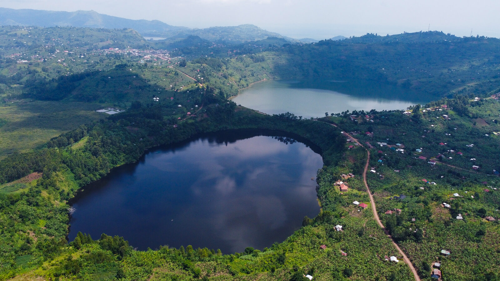
Kasyoha Kitomi Forest is a large, barely visited block of medium altitude rainforest between Queen Elizabeth National Park and Bushenyi, holding crater lakes, waterfalls and over 300 bird species. Almost nothing is set up for visitors, so going there means arranging a guide locally and camping. The reserve covers roughly 400 square kilometres of the Albertine Rift, and its chimpanzees are not habituated.
What a Kasyoha Kitomi Forest Safari Actually Involves
Start with the honest version, because every other page about this forest lists activities as though you could book them. A Kasyoha Kitomi forest safari is not a product you buy. There is no visitor centre, no published tariff, no permit, no lodge, no scheduled walk and no ranger waiting at a gate. There is a forest, a campsite, a trail system and a handful of people in the neighbouring villages who know their way through it.
That is not a reason to write the place off. It is a reason to arrive with a plan. Travellers who turn up expecting a Queen Elizabeth style operation leave frustrated within an hour. Travellers who have arranged a local guide in advance, brought their own camping kit and blocked out two days get one of the least visited good forests in Uganda largely to themselves.
The practical route in is through a Ugandan operator who works the Bushenyi area, or through the forestry authority office, and the arrangement will be made by phone rather than online. Give it more lead time than you would think necessary.
Chimpanzee Tracking in Kasyoha Kitomi and Why It Is Not Yet Sold
Chimpanzees live throughout this forest and you will very likely hear them. Chimpanzee tracking, in the sense of paying for a permit and walking out to a group that tolerates people, does not happen here. None of the community has been habituated to the point where visits are viable, a habituation project has been talked about for years without producing a bookable product, and nobody sells a permit.
What that means on the ground is worth being clear about. Calls carry a long way through this forest, and a morning walk will often put you within a few hundred metres of a party feeding. You will not get close. Wild chimpanzees move off from people at distance and they do it fast, and any guide who tells you otherwise is selling something.
If chimpanzees are the point of your trip, book Kalinzu Forest an hour south along the same corridor, where two communities are habituated and permits are sold, or Kibale further north, which does it better than anywhere in the country. Treat any chimpanzee sound at Kasyoha Kitomi as an atmosphere rather than a sighting.
Primate Watching and Forest Wildlife on a Kasyoha Kitomi Trek
The monkeys are the reliable part. A morning forest trek here usually turns up black and white colobus, red tailed monkeys and blue monkeys, with L’Hoest’s monkeys on the ground along the quieter stretches and olive baboons and vervets around the edges. Colobus are the easiest to see and the easiest to photograph, because they sit high and hold still.
Bigger animals are here and are almost never seen. Forest elephants move through, and so do forest buffalo, giant forest hog, bushpig, bushbuck and duiker. Leopard are recorded. In closed forest with short sightlines and no vehicle tracks, the realistic expectation is tracks and dung rather than animals.
The small mammals are what makes this reserve interesting to specialists. Three uncommon forest dependent shrews have been recorded here, the northern swamp musk shrew, the eastern musk shrew and the hero shrew, along with Woosnam’s brush furred rat. Nobody is going to show you one on a walk. It matters because a forest that still holds those species is a forest that has not been hollowed out, which is not true of every reserve in this part of Uganda.
Birding Safaris in the Kasyoha Kitomi Albertine Rift Forest
Birding safaris in Kasyoha Kitomi are the strongest argument for going at all, and the reason the occasional specialist tour still comes. The reserve’s list runs to over 308 species across an altitude band from around 975 metres up to 2,136, which is an unusually wide spread and produces a mix you cannot get from a single site elsewhere in the corridor.
Blue headed sunbird is the Albertine Rift endemic here and the bird serious listers come for. Grey parrot and white naped pigeon are both present and both carry conservation concern, which makes seeing them worth more than the tick. Afep pigeon, black bee eater, blue throated roller, dusky long tailed cuckoo and mountain illadopsis round out the forest birds people record.
Practically, this is hard birding. No hides, no boardwalks, no habituated species, no local bird guide network of the kind Bwindi has built. You want your own binoculars, a field guide, a recording of the calls, and the patience for a forest where most of what you hear stays invisible. A birder who works at it does very well here. A general visitor hoping for colourful birds will find it slow.
Crater Lake Hiking to Kamunzuku and the Twin Lakes
Three crater lakes sit inside the forest and they are the scenic draw. Lake Kamunzuku is the one most walks head for, reached by a trail from the Magambo campsite that takes around three hours each way through good forest. The water is clear enough to swim in and people do.
The Twin Lakes, named Kamweru and Kyema on most sources and Mweru and Chemo on others, sit closer together and can be taken in on a shorter walk. There is a lakeside trail of about three kilometres that runs roughly an hour and gives the best of the views without committing your whole day.
The crater lake hike to Kamunzuku is the single walk to do if you only have one. Six hours on the round trip, moderate ground, and a lake at the end that almost nobody in Uganda has been to. Take water and food in, because there is nothing along it.
Forest Trail Hiking, the Waterfall and the Lubale River
The trail system runs to about seventeen kilometres in total, and from the trading centre at Nyancasharu on the main highway the trailhead is a little over three kilometres in. From there the walks fan out.
Two rivers matter. The Lubale runs through the reserve, and the Kyambura River, which cut the gorge people visit inside Queen Elizabeth, rises in this forest. Rurama Hill gives the high ground and a view over the canopy for anyone willing to climb for it.
Underfoot it is what Ugandan forest usually is: undulating, muddy after rain, thick with vegetation off the path. There are no marked signs to speak of. Walking without a local guide is a poor idea, not because of the wildlife but because the trails are not obvious and the forest is large.
Canoeing and Fishing Trips with Local Fishermen
The crater lakes are fished, and going out with the people who fish them is one of the few activities here that has any structure to it. Dugout canoes, no life jackets unless you bring one, and an hour or two on water that almost never sees a visitor.
This is arranged in the village rather than through any office, and the price is whatever you negotiate. It is worth doing for the perspective more than the fishing. A forested crater lake seen from the middle of it, with the walls rising all round and nothing on the water but you, is the thing people remember from this reserve.
Swimming is possible in Kamunzuku and locals do it. Ask before you get in, since the lakes are used for other purposes and not every one of them is a good idea.
Camping Trips at Magambo and the Nyanzibiri Community Camp
There is no lodge in this forest and there is not going to be one soon. Accommodation is camping, and the two options are the site at Magambo inside the reserve and the Nyanzibiri eco community camp, which is run by the village and sits near its own crater lake.
Magambo is basic. The site takes a small number of tents, facilities amount to a latrine and water, and you bring everything else including the tent. It is the right base for the Kamunzuku walk because the trail starts there.
Nyanzibiri is the better arranged of the two and the money goes to the community. The same village runs the historic cave visit that Maramagambo travellers do, so a night here can be combined with that and with a walk round its crater. It is also the more likely of the two to be able to help you find a guide.
What both share is that nothing is guaranteed. Confirm by phone before you drive, carry your own food and water, and have a fallback in Ishaka or Bushenyi in case the arrangement falls through.
The Kitagata Hot Springs Tour and Why It Is Not Part of This Forest
Search for this reserve and the Kitagata hot springs come up alongside it constantly, usually in a way that implies they are inside it or next to it. They are neither. Kitagata is in Sheema District, a couple of kilometres southeast of Kitagata town on the Ishaka to Kagamba road, about 62 kilometres west of Mbarara. From the forest that is the wrong side of Bushenyi and a separate outing, not a stop on the same walk.
The springs themselves are worth seeing, but for what they are rather than what a tour listing suggests. Two springs sit side by side. One is called Ekyomugabe, historically reserved for the king of Ankole. The other is called Mulago, named after the national referral hospital, because people come to it to be treated. The water reaches around 80 degrees at its hottest, hot enough to boil an egg in, with one section cool enough to sit in.
Several hundred people a week use them, and they come for reasons that have nothing to do with tourism: skin conditions, joint pain, infertility. Bathing is separated by gender, the setting is a marram road and a swamp rather than anything landscaped, and there are no facilities of any kind. Treat it as somewhere people go to get better rather than a spa stop, behave accordingly, ask before photographing anyone, and it becomes one of the more genuine hours you will spend in western Uganda.
When to Plan a Kasyoha Kitomi Forest Trip
Rainfall here runs between about 1,250 and 1,400 millimetres a year across two wet spells, and temperatures sit between roughly 13 degrees at night and 26 in the afternoon. It is cooler than the savanna below it, particularly at the top of the altitude range, and it stays green all year.
The seasonal advice matters more at Kasyoha Kitomi than at a national park, because a park has graded roads and a lodge to retreat to and this reserve has neither. In a wet month the walk you planned may simply not be possible and there will be nobody to tell you until you arrive.
Getting to Kasyoha Kitomi Forest and Where to Stay
The reserve lies about 35 kilometres from Bushenyi town, south of Lake George and the Kazinga Channel, spread across the Bushenyi, Rubirizi, Ibanda and Kamwenge districts. It borders Queen Elizabeth National Park and the Kyambura Wildlife Reserve to the west, with Maramagambo and Kalinzu forests to the southeast, so the whole cluster sits within an hour of itself.
From the Mbarara to Kasese highway the turning is at the Nyancasharu trading centre, and the forest edge is only about a kilometre and a half in from the road, with the trailhead a little over three kilometres beyond that. Getting to the highway is straightforward on tarmac. Everything after the turning is earth and wants four wheel drive outside the dry months.
For beds, the campsites inside and beside the reserve are the only options at the forest. Ishaka and Bushenyi towns, half an hour away, carry ordinary Ugandan hotels, and the Homeland Hotel in Ishaka is the one most often named for this trip. The Queen Elizabeth lodges around Katunguru and Kyambura are the comfortable alternative if you would rather sleep well and drive in for the day.
The forest was first gazetted in 1932 as two separate blocks, Kasyoha and Kitomi, and joined under one name in 1948, with further land added later. It has been under real pressure from the farming communities around it ever since, and a Danish funded conservation project has worked with local associations on beekeeping, handicrafts and herbal medicine as alternatives to cutting the forest. Money you spend with the community camps goes into the same idea.
Questions Travellers Ask About Kasyoha Kitomi Forest Safaris
Is Kasyoha Kitomi worth visiting?
For a specific kind of traveller, yes. Birders, independent travellers with their own transport and a tent, and people who have already done the western circuit and want somewhere empty will get a lot from it. For a first Uganda trip, or a trip of ten days or fewer, no. Kalinzu and Maramagambo are half an hour away, deliver more for less effort, and have someone at the gate. That is a straight answer rather than a discouraging one: this reserve rewards the people it suits and wastes the time of the people it does not.
What does it cost to visit?
Nobody publishes a tariff, which is itself the answer. There is no permit and no fixed entry fee in the way a national park has one. In practice you pay a guide directly, you pay the community camp for the night, and you negotiate anything on the water. Budget on a modest sum in the region of 20 to 50 US dollars a day for a guide and a camping night combined, carry cash in Ugandan shillings since nothing here takes a card, and expect the figure to be agreed on the spot rather than quoted in advance. Compare that with a chimpanzee permit next door at Kalinzu, currently around 130 dollars for foreign non residents, and the economics of the two visits are entirely different propositions.
Can you see chimpanzees here?
Hear, yes. See, rarely and only at distance. No group is habituated, no permit exists and no tracking is offered. Anyone selling you chimpanzee tracking at Kasyoha Kitomi is selling you a walk in a forest where chimps happen to live, which is a different thing. For a real trek, go to Kalinzu or Kibale.
Do you need a guide, and how do you find one?
Yes, and not for safety so much as navigation. The trails are unmarked, the forest is large and the paths close in quickly. Guides are found through the Nyanzibiri community camp, through the forestry authority office, or through a Ugandan operator who works the Bushenyi area. Arrange it before you drive out, because there is nobody stationed at the roadside waiting to be hired.
How fit do you need to be?
Moderately. The Kamunzuku walk is six hours on the round trip over undulating ground, which is a real day but not a technical one. The shorter lakeside and waterfall trails suit most people. Mud is the limiting factor rather than gradient, so a walk that is easy in July can be hard work in April.
What should you bring?
More than you would for a park. Tent and sleeping bag, all your food and water, a water filter or purification, boots, long trousers against the safari ants, rain gear whatever the month, a torch, insect repellent, cash in small notes, and a phone that you do not rely on. Binoculars if birds are any part of your reason for coming. A basic first aid kit, since the nearest clinic is in Ishaka.
Are the Kitagata hot springs part of the same trip?
Not really. They lie in a different district on the far side of Bushenyi, roughly an hour and a half away, so pairing them means a separate outing rather than a detour. Do it as a stop on the road between Bushenyi and Mbarara if the route works, not as an add on to a forest day.
Uganda Safaris lists licensed Ugandan operators who work the Bushenyi and Queen Elizabeth corridor and can tell you honestly whether Kasyoha Kitomi fits your dates, or whether Kalinzu and Maramagambo serve you better for the time you have. Browse what is on offer in this part of the country, compare how each operator handles the forests, and ask the ones whose routing matches your plans. Questions cost nothing and no deposit is taken to enquire.
No operator on the marketplace currently lists a safari to Kasyoha-Kitomi Forest.
See every Uganda safari